Iceland Volcanoes
-
Krafla
-
Krafla
-
Katla
-
Ljosufjoll
-
Tungnafellsjokull
-
Katla
-
Fremrinamar
-
Krafla
-
Vestmannaeyjar
-
Hofsjokull
-

Thordarhyrna
-

Hengill
-

Hekla
-
Tungnafellsjokull
-

Oraefajokull
-

Hekla
-
Hekla
-
Oddnyjarhnjukur-Langjokull
-

Askja
-
Fremrinamar
Iceland has 35 Holocene volcanoes. Note that as a scientific organization we provide these listings for informational purposes only, with no international legal or policy implications. Volcanoes will be included on this list if they are within the boundaries of a country, on a shared boundary or area, in a remote territory, or within a maritime Exclusive Economic Zone. Bolded volcanoes have erupted within the past 20 years. Suggestions and data updates are always welcome ().
| Volcano Name | Location | Last Eruption | Primary Volcano Type |
|---|---|---|---|
| Askja | Iceland (northeastern) | 1961 CE | Stratovolcano |
| Bardarbunga | Iceland (northeastern) | 2015 CE | Stratovolcano |
| Brennisteinsfjoll | Reykjanes Peninsula | 1341 CE | Crater rows |
| Eldey | Reykjanes Peninsula | 1926 CE | Fissure vent |
| Esjufjoll | Öraefajokull-Snaefell Volcanic Flank Zone | Unknown - Unrest / Holocene | Stratovolcano |
| Eyjafjallajokull | Iceland (southern) | 2010 CE | Stratovolcano |
| Fagradalsfjall | Iceland (southwestern) | 2023 CE | Fissure vent |
| Fremrinamar | Iceland (northeastern) | 1200 BCE | Stratovolcano |
| Grimsnes | Iceland (southwestern) | 3500 BCE | Volcanic field |
| Grimsvotn | Iceland (northeastern) | 2011 CE | Caldera |
| Heidarspordar | Iceland (northeastern) | 300 BCE | Fissure vent |
| Hekla | Iceland (southern) | 2000 CE | Stratovolcano |
| Helgrindur | Snaefellsnes Peninsula | Unknown - Evidence Credible | Volcanic field |
| Hengill | Reykjanes Peninsula | 150 CE | Crater rows |
| Hofsjokull | Iceland (southwestern) | Unknown - Evidence Credible | Fissure vent(s) |
| Hromundartindur | Reykjanes Peninsula | Unknown - Evidence Uncertain | Stratovolcano |
| Katla | Iceland (southern) | 1918 CE | Fissure vent(s) |
| Kolbeinsey Ridge | North of Iceland | 1755 CE | Fissure vent |
| Krafla | Iceland (northeastern) | 1984 CE | Caldera |
| Krysuvik-Trolladyngja | Reykjanes Peninsula | 1340 CE | Crater rows |
| Kverkfjoll | Iceland (northeastern) | 1968 CE | Stratovolcano |
| Ljosufjoll | Snaefellsnes Peninsula | 960 CE | Volcanic field |
| Oddnyjarhnjukur-Langjokull | Iceland (southwestern) | 950 CE | Fissure vent(s) |
| Oraefajokull | Öraefajokull-Snaefell Volcanic Flank Zone | 1728 CE | Stratovolcano |
| Prestahnukur | Iceland (southwestern) | 3350 BCE | Fissure vent(s) |
| Reykjanes | Reykjanes Peninsula | 2024 CE | Crater rows |
| Snaefell | Öraefajokull-Snaefell Volcanic Flank Zone | Unknown - Evidence Uncertain | Stratovolcano |
| Snaefellsjokull | Snaefellsnes Peninsula | 200 CE | Stratovolcano |
| Theistareykir | Iceland (northeastern) | 900 BCE | Shield |
| Thordarhyrna | Grímsvötn-Laki Volcanic System | 1904 CE | Stratovolcano |
| Tindfjallajokull | Iceland (southern) | Unknown - Evidence Uncertain | Stratovolcano |
| Tjornes Fracture Zone | Iceland (northeastern) | 1868 CE | Fissure vent |
| Torfajokull | Iceland (southern) | 1477 CE | Stratovolcano |
| Tungnafellsjokull | Iceland (northeastern) | Unknown - Evidence Credible | Stratovolcano |
| Vestmannaeyjar | Iceland (southern) | 1973 CE | Fissure vent(s) |
Chronological listing of known Holocene eruptions (confirmed or uncertain) from volcanoes in Iceland. Bolded eruptions indicate continuing activity.
| Volcano Name | Start Date | Stop Date | Certainty | VEI | Evidence |
|---|---|---|---|---|---|
| Reykjanes | 2023 Dec 18 | 2024 Apr 19 (continuing) | Confirmed | 0 | Observations: Reported |
| Fagradalsfjall | 2023 Jul 10 | 2023 Aug 5 | Confirmed | Observations: Reported | |
| Fagradalsfjall | 2022 Aug 3 | 2022 Aug 21 | Confirmed | 0 | Observations: Reported |
| Fagradalsfjall | 2021 Mar 19 | 2021 Sep 18 | Confirmed | 0 | Observations: Reported |
| Bardarbunga | 2014 Aug 29 | 2015 Feb 27 | Confirmed | 0 | Observations: Reported |
| Grimsvotn | 2011 May 21 | 2011 May 25 | Confirmed | 4 | Observations: Reported |
| Eyjafjallajokull | 2010 Mar 20 | 2010 Jun 23 | Confirmed | 4 | Observations: Reported |
| Bardarbunga | [2008 Aug 16 ± 15 days] | [Unknown] | Uncertain | ||
| Bardarbunga | [2006 Apr 16 ± 15 days] | [Unknown] | Uncertain | ||
| Bardarbunga | [2005 Jul 16 ± 15 days] | [2005 Aug 16 ± 15 days] | Uncertain | ||
| Grimsvotn | 2004 Nov 1 | 2004 Nov 4 | Confirmed | 3 | Observations: Reported |
| Bardarbunga | [2002 Jul 16 ± 15 days] | [2002 Sep 16 ± 15 days] | Uncertain | ||
| Bardarbunga | [2000 Aug 16 ± 15 days] | [Unknown] | Uncertain | ||
| Hekla | 2000 Feb 26 | 2000 Mar 8 | Confirmed | 3 | Observations: Reported |
| Katla | [1999 Jul 17 (?)] | [1999 Aug 15 ± 5 days] | Uncertain | ||
| Grimsvotn | 1998 Dec 18 | 1998 Dec 28 | Confirmed | 3 | Observations: Reported |
| Bardarbunga | [1997 Aug 16 ± 15 days] | [Unknown] | Uncertain | ||
| Grimsvotn | 1996 Sep 30 | 1996 Nov 6 | Confirmed | 3 | Observations: Reported |
| Bardarbunga | [1996 Aug 16 ± 15 days] | [Unknown] | Uncertain | ||
| Bardarbunga | [1995 Jul 16 ± 15 days] | [Unknown] | Uncertain | ||
| Bardarbunga | [1991 Aug 12] | [Unknown] | Uncertain | ||
| Hekla | 1991 Jan 17 | 1991 Mar 11 | Confirmed | 3 | Observations: Reported |
| Bardarbunga | [1986 Nov 29] | [1986 Dec 1 (?)] | Uncertain | ||
| Krafla | 1984 Sep 4 | 1984 Sep 18 | Confirmed | 0 | Observations: Reported |
| Grimsvotn | [1984 Aug 20 (in or before)] | [Unknown] | Uncertain | ||
| Grimsvotn | 1983 May 28 | 1983 Jun 2 | Confirmed | 2 | Observations: Reported |
| Krafla | 1981 Nov 18 | 1981 Nov 23 | Confirmed | 0 | Observations: Reported |
| Hekla | 1981 Apr 9 | 1981 Apr 16 | Confirmed | 2 | Observations: Reported |
| Krafla | 1981 Jan 30 | 1981 Feb 4 | Confirmed | 0 | Observations: Reported |
| Hekla | 1980 Aug 17 | 1980 Aug 20 | Confirmed | 3 | Observations: Reported |
| Krafla | 1980 Mar 16 | 1980 Oct 23 | Confirmed | 0 | Observations: Reported |
| Krafla | 1977 Apr 27 | 1977 Sep 8 | Confirmed | 1 | Observations: Reported |
| Krafla | 1975 Dec 20 | 1975 Dec 20 | Confirmed | 0 | Observations: Reported |
| Vestmannaeyjar | 1973 Jan 23 | 1973 Jun 28 | Confirmed | 3 | Observations: Reported |
| Grimsvotn | [1972 Mar 16 ± 15 days] | [1972 Apr 16 ± 15 days] | Uncertain | ||
| Reykjanes | [1970 Jul 2 (?) ± 182 days] | [Unknown] | Uncertain | ||
| Hekla | 1970 May 5 | 1970 Jul 5 | Confirmed | 3 | Observations: Reported |
| Kverkfjoll | 1968 May 23 | 1968 Jun 16 ± 15 days | Confirmed | 0 | Observations: Reported |
| Reykjanes | [1966 Jul 2 ± 182 days] | [Unknown] | Uncertain | ||
| Vestmannaeyjar | 1963 Nov 8 | 1967 Jun 5 | Confirmed | 3 | Observations: Reported |
| Askja | 1961 Oct 26 | 1961 Dec 5 ± 4 days | Confirmed | 2 | Observations: Reported |
| Kverkfjoll | 1959 Jul 2 ± 182 days | Unknown | Confirmed | Observations: Reported | |
| Katla | [1955 Jun 25] | [Unknown] | Uncertain | ||
| Grimsvotn | [1954 Jul 16] | [Unknown] | Uncertain | ||
| Grimsvotn | 1954 Jan 15 ± 45 days | Unknown | Confirmed | 1 | Observations: Reported |
| Grimsvotn | [1948 Feb] | [Unknown] | Uncertain | ||
| Hekla | 1947 Mar 29 | 1948 Apr 21 | Confirmed | 4 | Observations: Reported |
| Grimsvotn | [1945 Sep 25 (?)] | [Unknown] | Uncertain | ||
| Grimsvotn | [1941 Apr] | [1941 Aug] | Uncertain | ||
| Grimsvotn | [1939 Jun] | [Unknown] | Uncertain | ||
| Askja | 1938 Dec 19 (?) | Unknown | Confirmed | 2 | Observations: Reported |
| Grimsvotn | 1938 May | Unknown | Confirmed | 1 | Observations: Reported |
| Grimsvotn | 1934 Dec 21 | 1934 Dec 26 | Confirmed | Unknown | |
| Grimsvotn | 1934 Mar 30 | 1934 Apr 7 | Confirmed | 2 | Observations: Reported |
| Grimsvotn | 1933 Nov 29 ± 1 days | 1933 Dec 9 ± 1 days | Confirmed | 1 | Observations: Reported |
| Kverkfjoll | 1929 Jan | 1929 Feb | Confirmed | 1 | Observations: Reported |
| Esjufjoll | [1927 Sep 5 ± 4 days] | [Unknown] | Uncertain | ||
| Askja | 1926 Jul 15 ± 45 days | Unknown | Confirmed | 2 | Observations: Reported |
| Eldey | 1926 Jun 5 ± 4 days | Unknown | Confirmed | 0 | Observations: Reported |
| Askja | 1924 (?) | Unknown | Confirmed | 0 | Observations: Reported |
| Askja | 1923 Jan 15 ± 45 days | Unknown | Confirmed | 0 | Observations: Reported |
| Askja | 1922 Nov | Unknown | Confirmed | 0 | Observations: Reported |
| Grimsvotn | 1922 Sep 29 | 1922 Oct 23 | Confirmed | 2 | Observations: Reported |
| Askja | 1921 Mar | Unknown | Confirmed | 0 | Observations: Reported |
| Askja | 1919 | Unknown | Confirmed | 2 | Observations: Reported |
| Grimsvotn | 1919 | Unknown | Confirmed | 2 | Unknown |
| Katla | 1918 Oct 12 | 1918 Nov 4 | Confirmed | 4 | Observations: Reported |
| Hekla | 1913 Apr 25 | 1913 May 18 | Confirmed | 2 | Observations: Reported |
| Bardarbunga | 1910 Jun 18 | 1910 Oct | Confirmed | 2 | Observations: Reported |
| Grimsvotn | 1910 | Unknown | Confirmed | Observations: Reported | |
| Thordarhyrna | 1902 Dec | 1904 Jan 12 | Confirmed | 4 | Observations: Reported |
| Bardarbunga | 1902 Dec | 1903 Jun | Confirmed | 2 | Unknown |
| Grimsvotn | 1897 | Unknown | Confirmed | 2 | Unknown |
| Vestmannaeyjar | 1896 Sep | Unknown | Confirmed | Observations: Reported | |
| Grimsvotn | 1891 Nov (?) | 1892 Mar 16 | Confirmed | 2 | Observations: Reported |
| Thordarhyrna | 1887 Aug 15 | 1889 | Confirmed | 2 | Observations: Reported |
| Eldey | [1884 Jul 26] | [Unknown] | Uncertain | ||
| Grimsvotn | 1883 Jan 15 | 1883 Apr 15 ± 5 days | Confirmed | 2 | Observations: Reported |
| Eldey | 1879 May 30 (?) | 1879 Jun 15 ± 5 days | Confirmed | 1 | Observations: Reported |
| Hekla | 1878 Feb 27 | 1878 Apr | Confirmed | 2 | Observations: Reported |
| Askja | 1875 Jan 1 | 1875 Oct 17 | Confirmed | 5 | Observations: Reported |
| Grimsvotn | 1873 Jan 8 | 1873 Aug | Confirmed | 4 | Observations: Reported |
| Bardarbunga | 1872 (?) | Unknown | Confirmed | Unknown | |
| Tjornes Fracture Zone | 1867 Dec | 1868 Jan | Confirmed | Observations: Reported | |
| Grimsvotn | 1867 Aug 29 | Unknown | Confirmed | 1 | Observations: Reported |
| Bardarbunga | 1862 Jun 30 | 1864 Oct 15 ± 45 days | Confirmed | 2 | Observations: Reported |
| Grimsvotn | [1861 May] | [Unknown] | Uncertain | ||
| Katla | 1860 May 8 | 1860 May 27 | Confirmed | 4 | Observations: Reported |
| Grimsvotn | 1854 | Unknown | Confirmed | 2 | Observations: Reported |
| Hekla | 1845 Sep 2 | 1846 Apr 5 (?) | Confirmed | 4 | Observations: Reported |
| Grimsvotn | 1838 Jun | Unknown | Confirmed | 2 | Observations: Reported |
| Reykjanes | 1830 Mar 13 (?) | 1831 Mar (?) | Confirmed | 3 | Observations: Reported |
| Katla | 1823 Jun 26 | 1823 Jul 23 | Confirmed | 3 | Observations: Reported |
| Thordarhyrna | 1823 Feb 4 ± 4 days | Unknown | Confirmed | 2 | Observations: Reported |
| Eyjafjallajokull | 1821 Dec 19 | 1823 Jan 1 | Confirmed | 2 | Observations: Reported |
| Grimsvotn | 1816 May | 1816 Jun (?) | Confirmed | 2 | Observations: Reported |
| Bardarbunga | [1807] | [Unknown] | Uncertain | ||
| Bardarbunga | 1797 | Unknown | Confirmed | Unknown | |
| Askja | 1797 (?) | Unknown | Confirmed | 0 | Observations: Reported |
| Grimsvotn | [1794 Jul 15 ± 45 days] | [Unknown] | Uncertain | ||
| Bardarbunga | 1794 | Unknown | Confirmed | Observations: Reported | |
| Reykjanes | 1783 May 1 (in or before) | 1783 Aug 15 ± 60 days | Confirmed | 3 | Observations: Reported |
| Grimsvotn | 1783 May (?) | 1785 May 26 (?) | Confirmed | 4 | Observations: Reported |
| Grimsvotn | 1774 Feb | Unknown | Confirmed | 2 | Observations: Reported |
| Bardarbunga | 1769 | Unknown | Confirmed | 2 | Unknown |
| Grimsvotn | 1768 | Unknown | Confirmed | 2 | Unknown |
| Bardarbunga | 1766 Jul | Unknown | Confirmed | 2 | Observations: Reported |
| Hekla | 1766 Apr 5 | 1768 May | Confirmed | 4 | Observations: Reported |
| Katla | 1755 Oct 17 | 1756 Feb 13 | Confirmed | 5 | Observations: Reported |
| Kolbeinsey Ridge | 1755 Sep 18 | Unknown | Confirmed | Unknown | |
| Grimsvotn | 1753 Oct 15 ± 45 days | Unknown | Confirmed | 2 | Observations: Reported |
| Bardarbunga | 1750 ± 10 years | Unknown | Confirmed | Sidereal: Ice Core | |
| Krafla | 1746 Jul 10 | 1746 Jul 10 (?) | Confirmed | 1 | Observations: Reported |
| Bardarbunga | 1739 | Unknown | Confirmed | 2 | Sidereal: Ice Core |
| Grimsvotn | 1730 | Unknown | Confirmed | Observations: Reported | |
| Kverkfjoll | 1729 Aug | Unknown | Confirmed | 1 | Observations: Reported |
| Krafla | 1729 Jun 30 | 1729 Sep 25 ± 5 days | Confirmed | 2 | Observations: Reported |
| Kverkfjoll | 1729 Feb 15 ± 45 days | Unknown | Confirmed | 1 | Observations: Reported |
| Bardarbunga | 1729 | Unknown | Confirmed | 1 | Unknown |
| Krafla | 1728 Dec 18 | Unknown | Confirmed | 2 | Observations: Reported |
| Krafla | 1728 Apr 18 | Unknown | Confirmed | 2 | Observations: Reported |
| Krafla | 1727 Aug 21 | Unknown | Confirmed | 2 | Observations: Reported |
| Oraefajokull | 1727 Aug 3 | 1728 May 1 ± 30 days | Confirmed | 4 | Observations: Reported |
| Bardarbunga | 1726 Feb 1 ± 30 days | 1726 May 1 ± 30 days | Confirmed | 1 | Observations: Reported |
| Hekla | 1725 Apr 2 | Unknown | Confirmed | 1 | Observations: Reported |
| Grimsvotn | 1725 Feb | Unknown | Confirmed | 2 | Observations: Reported |
| Krafla | 1724 May 17 | 1724 May 18 | Confirmed | 2 | Observations: Reported |
| Katla | 1721 May 11 | 1721 Oct 15 ± 45 days | Confirmed | 5 | Observations: Reported |
| Bardarbunga | 1720 | Unknown | Confirmed | 2 | Sidereal: Ice Core |
| Bardarbunga | 1717 Aug 4 | 1717 Sep 17 (in or after) | Confirmed | 3 | Observations: Reported |
| Grimsvotn | 1716 Oct 6 | Unknown | Confirmed | 2 | Observations: Reported |
| Bardarbunga | 1716 Oct 5 ± 4 days | Unknown | Confirmed | 2 | Observations: Reported |
| Bardarbunga | 1712 Jan 15 ± 45 days | Unknown | Confirmed | 2 | Observations: Reported |
| Bardarbunga | 1707 | Unknown | Confirmed | 2 | Observations: Reported |
| Grimsvotn | 1706 Oct 15 ± 45 days | Unknown | Confirmed | 2 | Observations: Reported |
| Bardarbunga | 1706 | Unknown | Confirmed | 2 | Observations: Reported |
| Bardarbunga | 1702 | Unknown | Confirmed | 2 | Unknown |
| Bardarbunga | 1697 | Unknown | Confirmed | 2 | Sidereal: Ice Core |
| Grimsvotn | 1697 | Unknown | Confirmed | Observations: Reported | |
| Hekla | 1693 Feb 13 | 1693 Sep 14 (?) | Confirmed | 4 | Observations: Reported |
| Grimsvotn | 1684 Nov 5 ± 4 days | 1685 Jan | Confirmed | 2 | Observations: Reported |
| Grimsvotn | 1681 Apr 10 | Unknown | Confirmed | Observations: Reported | |
| Grimsvotn | 1665 | Unknown | Confirmed | Observations: Reported | |
| Katla | 1660 Nov 3 | 1661 | Confirmed | 4 | Observations: Reported |
| Grimsvotn | 1659 Nov | Unknown | Confirmed | 2 | Observations: Reported |
| Kverkfjoll | 1655 Apr 15 ± 45 days | Unknown | Confirmed | 0 | Observations: Reported |
| Grimsvotn | 1638 Feb 24 ± 4 days | Unknown | Confirmed | 2 | Observations: Reported |
| Vestmannaeyjar | 1637 Oct | 1638 Feb 28 ± 60 days | Confirmed | Observations: Reported | |
| Hekla | 1636 May 8 | 1637 Jun | Confirmed | 3 | Observations: Reported |
| Grimsvotn | 1632 (?) | Unknown | Confirmed | Sidereal: Ice Core | |
| Grimsvotn | 1629 | Unknown | Confirmed | 2 | Observations: Reported |
| Katla | 1625 Sep 2 | 1625 Sep 14 | Confirmed | 5 | Observations: Reported |
| Grimsvotn | 1622 (?) | Unknown | Confirmed | Sidereal: Ice Core | |
| Grimsvotn | 1619 Jul 29 | Unknown | Confirmed | 2 | Observations: Reported |
| Katla | 1612 Oct 12 | Unknown | Confirmed | 4 | Observations: Reported |
| Eyjafjallajokull | 1612 | Unknown | Confirmed | 2 | Observations: Reported |
| Grimsvotn | 1610 (?) | Unknown | Confirmed | Sidereal: Ice Core | |
| Grimsvotn | 1603 Oct 31 | 1603 Nov | Confirmed | 2 | Unknown |
| Grimsvotn | 1598 Nov 7 | Unknown | Confirmed | 3 | Observations: Reported |
| Hekla | 1597 Jan 3 | 1597 Jun (in or after) | Confirmed | 4 | Observations: Reported |
| Reykjanes | 1583 Jul 15 ± 45 days | Unknown | Confirmed | 2 | Observations: Reported |
| Katla | 1580 Aug 11 | Unknown | Confirmed | 4 | Observations: Reported |
| Hekla | 1554 May | 1554 Jun (?) | Confirmed | 2 | Observations: Reported |
| Katla | 1550 (?) | Unknown | Confirmed | 4 | Correlation: Tephrochronology |
| Grimsvotn | 1530 ± 10 years | Unknown | Confirmed | Sidereal: Ice Core | |
| Grimsvotn | 1521 (?) | Unknown | Confirmed | Sidereal: Ice Core | |
| Hekla | 1510 Jul 25 | Unknown | Confirmed | 4 | Observations: Reported |
| Grimsvotn | 1510 ± 10 years | Unknown | Confirmed | Sidereal: Ice Core | |
| Grimsvotn | 1509 (?) | Unknown | Confirmed | Sidereal: Ice Core | |
| Grimsvotn | 1500 (?) | Unknown | Confirmed | Sidereal: Ice Core | |
| Katla | 1500 (?) | Unknown | Confirmed | 4 | Correlation: Tephrochronology |
| Grimsvotn | 1490 ± 10 years | Unknown | Confirmed | Sidereal: Ice Core | |
| Torfajokull | 1477 Mar | Unknown | Confirmed | 2 | Observations: Reported |
| Bardarbunga | 1477 Feb (?) | Unknown | Confirmed | 6 | Observations: Reported |
| Grimsvotn | 1471 (?) | Unknown | Confirmed | Sidereal: Ice Core | |
| Grimsvotn | 1470 ± 10 years | Unknown | Confirmed | Sidereal: Ice Core | |
| Grimsvotn | 1469 (?) | Unknown | Confirmed | Sidereal: Ice Core | |
| Grimsvotn | 1450 ± 10 years | Unknown | Confirmed | Sidereal: Ice Core | |
| Katla | 1450 ± 50 years | Unknown | Confirmed | Correlation: Tephrochronology | |
| Katla | 1440 | Unknown | Confirmed | 4 | Observations: Reported |
| Hekla | 1440 (?) | Unknown | Confirmed | Correlation: Tephrochronology | |
| Grimsvotn | 1430 ± 10 years | Unknown | Confirmed | Sidereal: Ice Core | |
| Eldey | 1422 | Unknown | Confirmed | 2 | Observations: Reported |
| Katla | 1416 | Unknown | Confirmed | 4 | Observations: Reported |
| Bardarbunga | 1410 (?) | Unknown | Confirmed | Correlation: Tephrochronology | |
| Grimsvotn | 1390 ± 10 years | Unknown | Confirmed | Sidereal: Ice Core | |
| Hekla | 1389 Dec 1 ± 30 days | 1390 | Confirmed | 3 | Observations: Reported |
| Kolbeinsey Ridge | 1372 | Unknown | Confirmed | 2 | Observations: Reported |
| Grimsvotn | 1370 ± 10 years | Unknown | Confirmed | Sidereal: Ice Core | |
| Grimsvotn | 1369 (?) | Unknown | Confirmed | Sidereal: Ice Core | |
| Oraefajokull | 1362 Jun 5 ± 4 days | 1362 Oct 15 ± 45 days | Confirmed | 5 | Observations: Reported |
| Katla | 1357 ± 3 years | Unknown | Confirmed | 4 | Observations: Reported |
| Grimsvotn | 1354 (?) | Unknown | Confirmed | Observations: Reported | |
| Grimsvotn | 1350 (?) | Unknown | Confirmed | Sidereal: Ice Core | |
| Bardarbunga | 1350 ± 10 years | Unknown | Confirmed | Sidereal: Ice Core | |
| Hekla | 1341 May 19 | Unknown | Confirmed | 3 | Observations: Reported |
| Grimsvotn | 1341 May | Unknown | Confirmed | 2 | Observations: Reported |
| Brennisteinsfjoll | 1341 ± 1 years | Unknown | Confirmed | 2 | Observations: Reported |
| Eldey | 1340 (?) | Unknown | Confirmed | 3 | Observations: Reported |
| Krysuvik-Trolladyngja | 1340 (?) | Unknown | Confirmed | 1 | Correlation: Tephrochronology |
| Grimsvotn | 1332 Nov | Unknown | Confirmed | 2 | Observations: Reported |
| Krysuvik-Trolladyngja | 1325 (?) | Unknown | Confirmed | 1 | Correlation: Tephrochronology |
| Katla | 1311 Jan 18 | Unknown | Confirmed | Observations: Reported | |
| Grimsvotn | 1310 ± 10 years | Unknown | Confirmed | Sidereal: Ice Core | |
| Hekla | 1300 Jul 11 | 1301 Jul | Confirmed | 4 | Observations: Reported |
| Askja | 1300 (?) | Unknown | Confirmed | 1 | Correlation: Tephrochronology |
| Krafla | 1300 ± 200 years | Unknown | Confirmed | 2 | Correlation: Tephrochronology |
| Bardarbunga | 1290 ± 10 years | Unknown | Confirmed | Sidereal: Ice Core | |
| Grimsvotn | 1290 ± 10 years | Unknown | Confirmed | Sidereal: Ice Core | |
| Grimsvotn | 1270 ± 10 years | Unknown | Confirmed | Sidereal: Ice Core | |
| Bardarbunga | 1270 ± 10 years | Unknown | Confirmed | Sidereal: Ice Core | |
| Katla | 1262 | Unknown | Confirmed | 5 | Observations: Reported |
| Bardarbunga | 1250 ± 50 years | Unknown | Confirmed | 1 | Correlation: Tephrochronology |
| Katla | 1245 | Unknown | Confirmed | 4 | Observations: Reported |
| Reykjanes | 1240 | Unknown | Confirmed | 1 | Observations: Reported |
| Reykjanes | 1238 | Unknown | Confirmed | 0 | Observations: Reported |
| Reykjanes | 1231 | Unknown | Confirmed | 3 | Observations: Reported |
| Grimsvotn | 1230 ± 10 years | Unknown | Confirmed | Sidereal: Ice Core | |
| Reykjanes | 1226 Jul 15 ± 45 days | 1227 (?) | Confirmed | 4 | Observations: Reported |
| Reykjanes | 1223 | Unknown | Confirmed | 3 | Observations: Reported |
| Hekla | 1222 | Unknown | Confirmed | 2 | Observations: Reported |
| Eldey | 1211 Aug 31 ± 30 days | Unknown | Confirmed | 4 | Observations: Reported |
| Reykjanes | 1211 | Unknown | Confirmed | Observations: Reported | |
| Katla | 1210 (?) | Unknown | Confirmed | 4 | Correlation: Tephrochronology |
| Bardarbunga | 1210 ± 10 years | Unknown | Confirmed | Sidereal: Ice Core | |
| Reykjanes | 1210 | Unknown | Confirmed | 3 | Observations: Reported |
| Hekla | 1206 Dec 4 | Unknown | Confirmed | 3 | Observations: Reported |
| Brennisteinsfjoll | 1200 (?) | Unknown | Confirmed | 2 | Correlation: Tephrochronology |
| Grimsvotn | 1190 (?) | Unknown | Confirmed | Sidereal: Ice Core | |
| Krysuvik-Trolladyngja | 1188 | Unknown | Confirmed | 1 | Observations: Reported |
| Reykjanes | 1179 (in or before) | Unknown | Confirmed | 2 | Observations: Reported |
| Katla | 1177 ± 2 years | Unknown | Confirmed | 3 | Observations: Reported |
| Torfajokull | 1170 (?) | Unknown | Confirmed | Correlation: Tephrochronology | |
| Bardarbunga | 1159 (?) | Unknown | Confirmed | Observations: Reported | |
| Hekla | 1158 Jan 19 | Unknown | Confirmed | 4 | Observations: Reported |
| Krysuvik-Trolladyngja | 1151 | Unknown | Confirmed | 1 | Observations: Reported |
| Katla | 1150 ± 50 years | Unknown | Confirmed | Correlation: Tephrochronology | |
| Grimsvotn | 1150 (?) | Unknown | Confirmed | Sidereal: Ice Core | |
| Hekla | 1104 Oct 15 ± 45 days | Unknown | Confirmed | 5 | Observations: Reported |
| Grimsvotn | 1090 (?) | Unknown | Confirmed | Sidereal: Ice Core | |
| Bardarbunga | 1080 (?) | Unknown | Confirmed | Correlation: Tephrochronology | |
| Krysuvik-Trolladyngja | 1075 ± 75 years | Unknown | Confirmed | 0 | Isotopic: 14C (uncalibrated) |
| Grimsvotn | 1060 (?) | Unknown | Confirmed | Correlation: Tephrochronology | |
| Hekla | 1050 ± 500 years | Unknown | Confirmed | Correlation: Tephrochronology | |
| Grimsvotn | 1010 (?) | Unknown | Confirmed | Sidereal: Ice Core | |
| Brennisteinsfjoll | 1000 Jun 25 ± 4 days | Unknown | Confirmed | 0 | Observations: Reported |
| Ljosufjoll | 0960 ± 10 years | Unknown | Confirmed | 3 | Correlation: Anthropology |
| Katla | 0960 (?) | Unknown | Confirmed | 3 | Correlation: Tephrochronology |
| Grimsvotn | 0960 (?) | Unknown | Confirmed | Sidereal: Ice Core | |
| Katla | 0950 (?) | Unknown | Confirmed | Correlation: Tephrochronology | |
| Brennisteinsfjoll | 0950 (?) | Unknown | Confirmed | 2 | Isotopic: 14C (uncalibrated) |
| Oddnyjarhnjukur-Langjokull | 0950 ± 50 years | Unknown | Confirmed | 2 | Correlation: Tephrochronology |
| Bardarbunga | 0940 (?) | Unknown | Confirmed | Correlation: Tephrochronology | |
| Katla | 0934 ± 2 years | 0940 (?) | Confirmed | 4 | Sidereal: Ice Core |
| Reykjanes | 0920 (?) | Unknown | Confirmed | Correlation: Tephrochronology | |
| Katla | 0920 | Unknown | Confirmed | 4 | Observations: Reported |
| Eyjafjallajokull | 0920 (?) | Unknown | Confirmed | 3 | Correlation: Tephrochronology |
| Brennisteinsfjoll | 0910 ± 75 years | Unknown | Confirmed | 2 | Isotopic: 14C (uncalibrated) |
| Grimsvotn | 0910 (?) | Unknown | Confirmed | Correlation: Tephrochronology | |
| Katla | [0904 (?)] | [Unknown] | Uncertain | ||
| Krysuvik-Trolladyngja | 0900 (?) | Unknown | Confirmed | 2 | Correlation: Tephrochronology |
| Bardarbunga | 0880 (?) | Unknown | Confirmed | Correlation: Tephrochronology | |
| Brennisteinsfjoll | 0875 ± 50 years | Unknown | Confirmed | 2 | Isotopic: 14C (uncalibrated) |
| Torfajokull | 0870 (?) | Unknown | Confirmed | 3 | Correlation: Tephrochronology |
| Bardarbunga | 0870 (?) | Unknown | Confirmed | 4 | Correlation: Tephrochronology |
| Krafla | 0850 (?) | Unknown | Confirmed | 0 | Correlation: Tephrochronology |
| Katla | 0820 (?) | Unknown | Confirmed | Correlation: Tephrochronology | |
| Hekla | 0800 ± 50 years | Unknown | Confirmed | Correlation: Tephrochronology | |
| Katla | 0780 (?) | Unknown | Confirmed | Correlation: Tephrochronology | |
| Hekla | 0750 (?) | Unknown | Confirmed | Correlation: Tephrochronology | |
| Katla | 0680 (?) | Unknown | Confirmed | Correlation: Tephrochronology | |
| Hekla | 0650 ± 500 years | Unknown | Confirmed | Correlation: Tephrochronology | |
| Katla | 0610 (?) | Unknown | Confirmed | Correlation: Tephrochronology | |
| Katla | 0590 (?) | Unknown | Confirmed | Correlation: Tephrochronology | |
| Eyjafjallajokull | 0550 (?) | Unknown | Confirmed | Correlation: Tephrochronology | |
| Hekla | 0550 ± 1500 years | Unknown | Confirmed | Correlation: Tephrochronology | |
| Katla | 0540 (?) | Unknown | Confirmed | Correlation: Tephrochronology | |
| Katla | 0500 (?) | Unknown | Confirmed | Correlation: Tephrochronology | |
| Katla | 0400 (?) | Unknown | Confirmed | Correlation: Tephrochronology | |
| Hekla | 0350 ± 1500 years | Unknown | Confirmed | Correlation: Tephrochronology | |
| Katla | 0290 (?) | Unknown | Confirmed | Correlation: Tephrochronology | |
| Katla | 0270 ± 12 years | Unknown | Confirmed | 3 | Isotopic: 14C (uncalibrated) |
| Katla | 0260 (?) | Unknown | Confirmed | Correlation: Tephrochronology | |
| Hekla | 0250 ± 2500 years | Unknown | Confirmed | Correlation: Tephrochronology | |
| Krafla | 0250 ± 300 years | Unknown | Confirmed | 0 | Correlation: Tephrochronology |
| Snaefellsjokull | 0200 ± 150 years | Unknown | Confirmed | Isotopic: 14C (uncalibrated) | |
| Katla | 0200 (?) | Unknown | Confirmed | Correlation: Tephrochronology | |
| Torfajokull | 0150 ± 100 years | Unknown | Confirmed | 3 | Correlation: Tephrochronology |
| Hengill | 0150 ± 75 years | Unknown | Confirmed | 2 | Isotopic: 14C (calibrated) |
| Bardarbunga | 0150 ± 100 years | Unknown | Confirmed | 2 | Correlation: Tephrochronology |
| Katla | 0130 (?) | Unknown | Confirmed | Correlation: Tephrochronology | |
| Katla | 0030 (?) | Unknown | Confirmed | Correlation: Tephrochronology | |
| Krafla | 0050 BCE (?) | Unknown | Confirmed | 2 | Correlation: Tephrochronology |
| Grimsvotn | 0050 BCE (?) | Unknown | Confirmed | 2 | Correlation: Tephrochronology |
| Katla | 0080 BCE (?) | Unknown | Confirmed | Correlation: Tephrochronology | |
| Hengill | 0080 BCE ± 75 years | Unknown | Confirmed | 2 | Isotopic: 14C (uncalibrated) |
| Hekla | 0150 BCE ± 2500 years | Unknown | Confirmed | Correlation: Tephrochronology | |
| Krysuvik-Trolladyngja | 0190 BCE ± 75 years | Unknown | Confirmed | 2 | Isotopic: 14C (uncalibrated) |
| Reykjanes | 0200 BCE (?) | Unknown | Confirmed | 0 | Isotopic: 14C (uncalibrated) |
| Katla | 0250 BCE (?) | Unknown | Confirmed | Correlation: Tephrochronology | |
| Hekla | 0250 BCE ± 500 years | Unknown | Confirmed | Correlation: Tephrochronology | |
| Heidarspordar | 0300 BCE (?) | Unknown | Confirmed | 2 | Isotopic: 14C (calibrated) |
| Katla | 0370 BCE (?) | Unknown | Confirmed | Correlation: Tephrochronology | |
| Reykjanes | 0400 BCE ± 100 years | Unknown | Confirmed | 2 | Isotopic: 14C (uncalibrated) |
| Katla | 0430 BCE (?) | Unknown | Confirmed | Correlation: Tephrochronology | |
| Krafla | 0500 BCE ± 300 years | Unknown | Confirmed | 0 | Correlation: Tephrochronology |
| Katla | 0530 BCE (?) | Unknown | Confirmed | Correlation: Tephrochronology | |
| Katla | 0550 BCE (?) | Unknown | Confirmed | Correlation: Tephrochronology | |
| Katla | 0560 BCE (?) | Unknown | Confirmed | Correlation: Tephrochronology | |
| Katla | 0600 BCE (?) | Unknown | Confirmed | Correlation: Tephrochronology | |
| Katla | 0650 BCE (?) | Unknown | Confirmed | Correlation: Tephrochronology | |
| Hekla | 0650 BCE ± 2500 years | Unknown | Confirmed | Correlation: Tephrochronology | |
| Krafla | 0650 BCE (?) | Unknown | Confirmed | 4 | Correlation: Tephrochronology |
| Ljosufjoll | 0665 BCE ± 100 years | Unknown | Confirmed | 2 | Isotopic: 14C (uncalibrated) |
| Katla | 0700 BCE (?) | Unknown | Confirmed | Correlation: Tephrochronology | |
| Katla | 0740 BCE (?) | Unknown | Confirmed | Correlation: Tephrochronology | |
| Hekla | 0750 BCE ± 500 years | Unknown | Confirmed | Correlation: Tephrochronology | |
| Katla | 0780 BCE (?) | Unknown | Confirmed | Correlation: Tephrochronology | |
| Katla | 0850 BCE ± 50 years | Unknown | Confirmed | 4 | Isotopic: 14C (calibrated) |
| Hekla | 0850 BCE ± 1500 years | Unknown | Confirmed | Correlation: Tephrochronology | |
| Katla | 0860 BCE (?) | Unknown | Confirmed | Correlation: Tephrochronology | |
| Theistareykir | 0900 BCE ± 100 years | Unknown | Confirmed | 0 | Correlation: Tephrochronology |
| Katla | 0920 BCE (?) | Unknown | Confirmed | Correlation: Tephrochronology | |
| Katla | 0990 BCE (?) | Unknown | Confirmed | Correlation: Tephrochronology | |
| Snaefellsjokull | 1000 BCE ± 500 years | Unknown | Confirmed | 2 | Isotopic: 14C (uncalibrated) |
| Brennisteinsfjoll | 1040 BCE ± 75 years | Unknown | Confirmed | 2 | Isotopic: 14C (uncalibrated) |
| Krysuvik-Trolladyngja | 1060 BCE ± 75 years | Unknown | Confirmed | 0 | Isotopic: 14C (uncalibrated) |
| Hekla | 1100 BCE ± 50 years | Unknown | Confirmed | 5 | Isotopic: 14C (calibrated) |
| Hekla | 1150 BCE ± 1500 years | Unknown | Confirmed | Correlation: Tephrochronology | |
| Torfajokull | 1150 BCE ± 100 years | Unknown | Confirmed | Correlation: Tephrochronology | |
| Katla | 1160 BCE (?) | Unknown | Confirmed | Correlation: Tephrochronology | |
| Katla | 1190 BCE (?) | Unknown | Confirmed | Correlation: Tephrochronology | |
| Fremrinamar | 1200 BCE (?) | Unknown | Confirmed | Correlation: Tephrochronology | |
| Bardarbunga | 1200 BCE (?) | Unknown | Confirmed | Correlation: Tephrochronology | |
| Katla | 1220 BCE ± 12 years | Unknown | Confirmed | 3 | Isotopic: 14C (calibrated) |
| Hekla | 1250 BCE ± 1500 years | Unknown | Confirmed | Correlation: Tephrochronology | |
| Askja | 1250 BCE ± 300 years | Unknown | Confirmed | 0 | Correlation: Tephrochronology |
| Katla | 1280 BCE (?) | Unknown | Confirmed | Correlation: Tephrochronology | |
| Katla | 1290 BCE (?) | Unknown | Confirmed | Correlation: Tephrochronology | |
| Hekla | 1350 BCE ± 2500 years | Unknown | Confirmed | Correlation: Tephrochronology | |
| Katla | 1440 BCE ± 40 years | Unknown | Confirmed | 4 | Isotopic: 14C (calibrated) |
| Katla | 1540 BCE (?) | Unknown | Confirmed | Correlation: Tephrochronology | |
| Hekla | 1550 BCE (?) | Unknown | Confirmed | 4 | Correlation: Tephrochronology |
| Torfajokull | 1550 BCE ± 500 years | Unknown | Confirmed | Correlation: Tephrochronology | |
| Katla | 1640 BCE (?) | Unknown | Confirmed | Correlation: Tephrochronology | |
| Hekla | 1650 BCE ± 2500 years | Unknown | Confirmed | Correlation: Tephrochronology | |
| Katla | 1670 BCE (?) | Unknown | Confirmed | Correlation: Tephrochronology | |
| Katla | 1700 BCE (?) | Unknown | Confirmed | Correlation: Tephrochronology | |
| Hengill | 1730 BCE ± 50 years | Unknown | Confirmed | 0 | Isotopic: 14C (calibrated) |
| Hekla | 1750 BCE ± 500 years | Unknown | Confirmed | Correlation: Tephrochronology | |
| Ljosufjoll | 1750 BCE ± 150 years | Unknown | Confirmed | 2 | Isotopic: 14C (uncalibrated) |
| Reykjanes | 1800 BCE ± 300 years | Unknown | Confirmed | 2 | Correlation: Tephrochronology |
| Hekla | 1850 BCE ± 2500 years | Unknown | Confirmed | Correlation: Tephrochronology | |
| Katla | 1850 BCE (?) | Unknown | Confirmed | Correlation: Tephrochronology | |
| Katla | 1910 BCE (?) | Unknown | Confirmed | Correlation: Tephrochronology | |
| Katla | 1920 BCE (?) | Unknown | Confirmed | 4 | Isotopic: 14C (calibrated) |
| Katla | 1950 BCE (?) | Unknown | Confirmed | Correlation: Tephrochronology | |
| Grimsvotn | 1950 BCE ± 100 years | Unknown | Confirmed | 2 | Correlation: Tephrochronology |
| Katla | 2000 BCE (?) | Unknown | Confirmed | Correlation: Tephrochronology | |
| Snaefellsjokull | 2010 BCE ± 100 years | Unknown | Confirmed | Isotopic: 14C (uncalibrated) | |
| Katla | 2020 BCE (?) | Unknown | Confirmed | Correlation: Tephrochronology | |
| Katla | 2050 BCE (?) | Unknown | Confirmed | Correlation: Tephrochronology | |
| Oddnyjarhnjukur-Langjokull | 2050 BCE (?) | Unknown | Confirmed | 0 | Isotopic: 14C (calibrated) |
| Askja | 2050 BCE ± 500 years | Unknown | Confirmed | 0 | Correlation: Tephrochronology |
| Ljosufjoll | 2050 BCE (?) | Unknown | Confirmed | 3 | Correlation: Tephrochronology |
| Katla | 2110 BCE (?) | Unknown | Confirmed | Correlation: Tephrochronology | |
| Katla | 2160 BCE (?) | Unknown | Confirmed | Correlation: Tephrochronology | |
| Katla | 2190 BCE (?) | Unknown | Confirmed | Correlation: Tephrochronology | |
| Katla | 2220 BCE (?) | Unknown | Confirmed | Correlation: Tephrochronology | |
| Katla | 2250 BCE (?) | Unknown | Confirmed | Correlation: Tephrochronology | |
| Snaefellsjokull | 2270 BCE ± 300 years | Unknown | Confirmed | 0 | Isotopic: 14C (uncalibrated) |
| Fremrinamar | 2300 BCE (?) | Unknown | Confirmed | 0 | Correlation: Tephrochronology |
| Hekla | 2310 BCE ± 20 years | Unknown | Confirmed | 5 | Isotopic: 14C (calibrated) |
| Snaefellsjokull | 2400 BCE ± 200 years | Unknown | Confirmed | 2 | Isotopic: 14C (uncalibrated) |
| Katla | 2420 BCE (?) | Unknown | Confirmed | Correlation: Tephrochronology | |
| Hekla | 2450 BCE ± 1500 years | Unknown | Confirmed | Correlation: Tephrochronology | |
| Katla | 2480 BCE (?) | Unknown | Confirmed | Correlation: Tephrochronology | |
| Katla | 2540 BCE (?) | Unknown | Confirmed | Correlation: Tephrochronology | |
| Oddnyjarhnjukur-Langjokull | 2550 BCE (?) | Unknown | Confirmed | 0 | Correlation: Tephrochronology |
| Brennisteinsfjoll | 2660 BCE ± 75 years | Unknown | Confirmed | 0 | Isotopic: 14C (uncalibrated) |
| Katla | 2680 BCE (?) | Unknown | Confirmed | Correlation: Tephrochronology | |
| Hekla | 2750 BCE ± 2500 years | Unknown | Confirmed | Correlation: Tephrochronology | |
| Katla | 2850 BCE (?) | Unknown | Confirmed | Correlation: Tephrochronology | |
| Katla | 2920 BCE (?) | Unknown | Confirmed | 3 | Correlation: Tephrochronology |
| Hekla | 2950 BCE ± 500 years | Unknown | Confirmed | Correlation: Tephrochronology | |
| Snaefellsjokull | 2970 BCE ± 300 years | Unknown | Confirmed | 0 | Isotopic: 14C (uncalibrated) |
| Krafla | 3050 BCE (?) | Unknown | Confirmed | 0 | Isotopic: 14C (uncalibrated) |
| Katla | 3180 BCE (?) | Unknown | Confirmed | Correlation: Tephrochronology | |
| Hengill | 3250 BCE (?) | Unknown | Confirmed | 0 | Isotopic: 14C (calibrated) |
| Katla | 3280 BCE (?) | Unknown | Confirmed | Correlation: Tephrochronology | |
| Prestahnukur | 3350 BCE (?) | Unknown | Confirmed | 0 | Correlation: Tephrochronology |
| Hekla | 3350 BCE ± 2500 years | Unknown | Confirmed | Correlation: Tephrochronology | |
| Katla | 3370 BCE (?) | Unknown | Confirmed | Correlation: Tephrochronology | |
| Katla | 3390 BCE (?) | Unknown | Confirmed | Correlation: Tephrochronology | |
| Hekla | 3450 BCE ± 1500 years | Unknown | Confirmed | Correlation: Tephrochronology | |
| Katla | 3480 BCE (?) | Unknown | Confirmed | Correlation: Tephrochronology | |
| Grimsnes | 3500 BCE (?) | Unknown | Confirmed | 2 | Correlation: Tephrochronology |
| Katla | 3510 BCE (?) | Unknown | Confirmed | Correlation: Tephrochronology | |
| Oddnyjarhnjukur-Langjokull | 3550 BCE (?) | Unknown | Confirmed | 0 | Correlation: Tephrochronology |
| Grimsvotn | 3550 BCE ± 500 years | Unknown | Confirmed | 0 | Correlation: Tephrochronology |
| Katla | 3640 BCE (?) | Unknown | Confirmed | Correlation: Tephrochronology | |
| Grimsnes | 3650 BCE (?) | Unknown | Confirmed | 0 | Correlation: Tephrochronology |
| Katla | 3670 BCE (?) | Unknown | Confirmed | Correlation: Tephrochronology | |
| Katla | 3720 BCE (?) | Unknown | Confirmed | Correlation: Tephrochronology | |
| Grimsnes | 3750 BCE (?) | Unknown | Confirmed | 0 | Correlation: Tephrochronology |
| Hengill | 3750 BCE (?) | Unknown | Confirmed | 2 | Isotopic: 14C (calibrated) |
| Hekla | 3750 BCE ± 1500 years | Unknown | Confirmed | Correlation: Tephrochronology | |
| Katla | 3790 BCE (?) | Unknown | Confirmed | Correlation: Tephrochronology | |
| Reykjanes | 3800 BCE ± 300 years | Unknown | Confirmed | Correlation: Tephrochronology | |
| Katla | 3810 BCE (?) | Unknown | Confirmed | Correlation: Tephrochronology | |
| Grimsnes | 3900 BCE (?) | Unknown | Confirmed | 0 | Correlation: Tephrochronology |
| Katla | 3930 BCE (?) | Unknown | Confirmed | Correlation: Tephrochronology | |
| Vestmannaeyjar | 3950 BCE ± 300 years | Unknown | Confirmed | Isotopic: Uranium-series | |
| Hekla | 3950 BCE ± 500 years | Unknown | Confirmed | Correlation: Tephrochronology | |
| Grimsnes | 4000 BCE (?) | Unknown | Confirmed | 2 | Correlation: Tephrochronology |
| Fremrinamar | 4000 BCE (?) | Unknown | Confirmed | 0 | Correlation: Tephrochronology |
| Reykjanes | 4000 BCE (?) | Unknown | Confirmed | 0 | Correlation: Tephrochronology |
| Heidarspordar | 4050 BCE (?) | Unknown | Confirmed | 0 | Correlation: Tephrochronology |
| Fremrinamar | 4050 BCE ± 1050 years | Unknown | Confirmed | Correlation: Tephrochronology | |
| Grimsnes | 4050 BCE (?) | Unknown | Confirmed | 0 | Correlation: Tephrochronology |
| Hekla | 4050 BCE ± 500 years | Unknown | Confirmed | Correlation: Tephrochronology | |
| Snaefellsjokull | 4050 BCE (?) | Unknown | Confirmed | 0 | Correlation: Tephrochronology |
| Katla | 4060 BCE (?) | Unknown | Confirmed | Correlation: Tephrochronology | |
| Hekla | 4110 BCE ± 100 years | Unknown | Confirmed | 5 | Isotopic: 14C (calibrated) |
| Hekla | 4150 BCE ± 2500 years | Unknown | Confirmed | Correlation: Tephrochronology | |
| Bardarbunga | 4200 BCE (?) | Unknown | Confirmed | Correlation: Tephrochronology | |
| Katla | 4210 BCE (?) | Unknown | Confirmed | Correlation: Tephrochronology | |
| Katla | 4240 BCE (?) | Unknown | Confirmed | Correlation: Tephrochronology | |
| Hekla | 4250 BCE ± 500 years | Unknown | Confirmed | Correlation: Tephrochronology | |
| Vestmannaeyjar | 4270 BCE ± 200 years | Unknown | Confirmed | 3 | Isotopic: 14C (calibrated) |
| Grimsnes | 4270 BCE ± 150 years | Unknown | Confirmed | 3 | Isotopic: 14C (uncalibrated) |
| Katla | 4280 BCE (?) | Unknown | Confirmed | Correlation: Tephrochronology | |
| Hekla | 4350 BCE ± 1500 years | Unknown | Confirmed | Correlation: Tephrochronology | |
| Katla | 4370 BCE (?) | Unknown | Confirmed | Correlation: Tephrochronology | |
| Bardarbunga | 4400 BCE (?) | Unknown | Confirmed | Correlation: Tephrochronology | |
| Katla | 4430 BCE (?) | Unknown | Confirmed | Correlation: Tephrochronology | |
| Grimsnes | 4450 BCE (?) | Unknown | Confirmed | 2 | Correlation: Tephrochronology |
| Grimsnes | 4500 BCE (?) | Unknown | Confirmed | 0 | Correlation: Tephrochronology |
| Snaefellsjokull | 4550 BCE ± 1500 years | Unknown | Confirmed | 2 | Correlation: Tephrochronology |
| Vestmannaeyjar | 4550 BCE ± 500 years | Unknown | Confirmed | Correlation: Tephrochronology | |
| Hekla | 4550 BCE ± 500 years | Unknown | Confirmed | Correlation: Tephrochronology | |
| Torfajokull | 4550 BCE ± 500 years | Unknown | Confirmed | Correlation: Tephrochronology | |
| Bardarbunga | 4550 BCE (?) | Unknown | Confirmed | Correlation: Tephrochronology | |
| Grimsvotn | 4550 BCE ± 500 years | Unknown | Confirmed | 0 | Correlation: Tephrochronology |
| Bardarbunga | 4600 BCE (?) | Unknown | Confirmed | Correlation: Tephrochronology | |
| Katla | 4610 BCE (?) | Unknown | Confirmed | Correlation: Tephrochronology | |
| Hekla | 4650 BCE ± 500 years | Unknown | Confirmed | Correlation: Tephrochronology | |
| Katla | 4660 BCE (?) | Unknown | Confirmed | Correlation: Tephrochronology | |
| Hekla | 4700 BCE (?) | Unknown | Confirmed | 4 | Correlation: Tephrochronology |
| Hekla | 4750 BCE ± 2500 years | Unknown | Confirmed | Correlation: Tephrochronology | |
| Katla | 4750 BCE (?) | Unknown | Confirmed | Correlation: Tephrochronology | |
| Bardarbunga | 4800 BCE (?) | Unknown | Confirmed | Correlation: Tephrochronology | |
| Katla | 4810 BCE (?) | Unknown | Confirmed | Correlation: Tephrochronology | |
| Torfajokull | 4850 BCE (?) | Unknown | Confirmed | Correlation: Tephrochronology | |
| Katla | 4880 BCE (?) | Unknown | Confirmed | Correlation: Tephrochronology | |
| Hekla | 4950 BCE ± 2500 years | Unknown | Confirmed | Correlation: Tephrochronology | |
| Hengill | 5000 BCE (?) | Unknown | Confirmed | Correlation: Tephrochronology | |
| Bardarbunga | 5000 BCE (?) | Unknown | Confirmed | Correlation: Tephrochronology | |
| Kverkfjoll | 5000 BCE ± 1000 years | Unknown | Confirmed | Correlation: Tephrochronology | |
| Katla | 5020 BCE (?) | Unknown | Confirmed | Correlation: Tephrochronology | |
| Reykjanes | 5040 BCE ± 90 years | Unknown | Confirmed | 0 | Isotopic: 14C (uncalibrated) |
| Katla | 5040 BCE (?) | Unknown | Confirmed | Correlation: Tephrochronology | |
| Hekla | 5050 BCE (?) | Unknown | Confirmed | Correlation: Tephrochronology | |
| Torfajokull | 5050 BCE (?) | Unknown | Confirmed | Correlation: Tephrochronology | |
| Katla | 5070 BCE (?) | Unknown | Confirmed | Correlation: Tephrochronology | |
| Hekla | 5150 BCE (?) | Unknown | Confirmed | 5 | Isotopic: 14C (calibrated) |
| Katla | 5180 BCE (?) | Unknown | Confirmed | Correlation: Tephrochronology | |
| Katla | 5230 BCE (?) | Unknown | Confirmed | Correlation: Tephrochronology | |
| Krysuvik-Trolladyngja | 5290 BCE ± 150 years | Unknown | Confirmed | 2 | Isotopic: 14C (uncalibrated) |
| Katla | 5360 BCE (?) | Unknown | Confirmed | Correlation: Tephrochronology | |
| Katla | 5460 BCE (?) | Unknown | Confirmed | Correlation: Tephrochronology | |
| Katla | 5470 BCE (?) | Unknown | Confirmed | Correlation: Tephrochronology | |
| Katla | 5550 BCE (?) | Unknown | Confirmed | Correlation: Tephrochronology | |
| Hengill | 5550 BCE ± 500 years | Unknown | Confirmed | 0 | Correlation: Tephrochronology |
| Katla | 5560 BCE (?) | Unknown | Confirmed | Correlation: Tephrochronology | |
| Katla | 5630 BCE (?) | Unknown | Confirmed | Correlation: Tephrochronology | |
| Katla | 5710 BCE (?) | Unknown | Confirmed | Correlation: Tephrochronology | |
| Katla | 5720 BCE (?) | Unknown | Confirmed | Correlation: Tephrochronology | |
| Katla | 5730 BCE (?) | Unknown | Confirmed | Correlation: Tephrochronology | |
| Heidarspordar | 5750 BCE (?) | Unknown | Confirmed | 0 | Correlation: Tephrochronology |
| Katla | 5850 BCE (?) | Unknown | Confirmed | Correlation: Tephrochronology | |
| Oddnyjarhnjukur-Langjokull | 5850 BCE (?) | Unknown | Confirmed | 2 | Correlation: Tephrochronology |
| Hekla | 5850 BCE ± 2500 years | Unknown | Confirmed | Correlation: Tephrochronology | |
| Katla | 5890 BCE (?) | Unknown | Confirmed | Correlation: Tephrochronology | |
| Katla | 5960 BCE (?) | Unknown | Confirmed | Correlation: Tephrochronology | |
| Krysuvik-Trolladyngja | 6000 BCE (?) | Unknown | Confirmed | 0 | Correlation: Tephrochronology |
| Snaefellsjokull | 6050 BCE ± 1000 years | Unknown | Confirmed | Correlation: Tephrochronology | |
| Katla | 6050 BCE (?) | Unknown | Confirmed | Correlation: Tephrochronology | |
| Vestmannaeyjar | 6050 BCE (?) | Unknown | Confirmed | Correlation: Tephrochronology | |
| Torfajokull | 6050 BCE (?) | Unknown | Confirmed | Correlation: Tephrochronology | |
| Heidarspordar | 6150 BCE (?) | Unknown | Confirmed | 0 | Correlation: Tephrochronology |
| Katla | 6170 BCE (?) | Unknown | Confirmed | Correlation: Tephrochronology | |
| Katla | 6200 BCE (?) | Unknown | Confirmed | Correlation: Tephrochronology | |
| Katla | 6230 BCE (?) | Unknown | Confirmed | Correlation: Tephrochronology | |
| Grimsnes | 6250 BCE (?) | Unknown | Confirmed | Isotopic: 14C (calibrated) | |
| Katla | 6380 BCE (?) | Unknown | Confirmed | Correlation: Tephrochronology | |
| Krafla | 6500 BCE (?) | Unknown | Confirmed | Correlation: Tephrochronology | |
| Bardarbunga | 6650 BCE ± 50 years | Unknown | Confirmed | Isotopic: 14C (calibrated) | |
| Krafla | 6800 BCE (?) | Unknown | Confirmed | 2 | Correlation: Tephrochronology |
| Theistareykir | 6800 BCE (?) | Unknown | Confirmed | 0 | Correlation: Tephrochronology |
| Krafla | 6850 BCE (?) | Unknown | Confirmed | 2 | Correlation: Tephrochronology |
| Heidarspordar | 6950 BCE (?) | Unknown | Confirmed | 0 | Correlation: Tephrochronology |
| Prestahnukur | 6950 BCE (?) | Unknown | Confirmed | 0 | Isotopic: 14C (calibrated) |
| Ljosufjoll | 7050 BCE (?) | Unknown | Confirmed | 2 | Correlation: Tephrochronology |
| Bardarbunga | 7050 BCE ± 1000 years | Unknown | Confirmed | Correlation: Tephrochronology | |
| Kverkfjoll | 7050 BCE (?) | Unknown | Confirmed | Correlation: Tephrochronology | |
| Bardarbunga | 7100 BCE (?) | Unknown | Confirmed | Correlation: Tephrochronology | |
| Hengill | 7100 BCE (?) | Unknown | Confirmed | 0 | Correlation: Tephrochronology |
| Hengill | 7300 BCE (?) | Unknown | Confirmed | Correlation: Tephrochronology | |
| Heidarspordar | 7400 BCE ± 300 years | Unknown | Confirmed | 0 | Correlation: Tephrochronology |
| Hengill | 7550 BCE (?) | Unknown | Confirmed | 0 | Correlation: Tephrochronology |
| Prestahnukur | 7550 BCE ± 500 years | Unknown | Confirmed | 0 | Isotopic: 14C (uncalibrated) |
| Vestmannaeyjar | 7550 BCE (?) | Unknown | Confirmed | 3 | Correlation: Tephrochronology |
| Grimsnes | 7750 BCE (?) | Unknown | Confirmed | 3 | Isotopic: 14C (calibrated) |
| Heidarspordar | 7850 BCE (?) | Unknown | Confirmed | Correlation: Tephrochronology | |
| Reykjanes | 8000 BCE (?) | Unknown | Confirmed | 0 | Correlation: Tephrochronology |
| Vestmannaeyjar | 8050 BCE (?) | Unknown | Confirmed | 4 | Correlation: Tephrochronology |
| Hengill | 8200 BCE (?) | Unknown | Confirmed | 0 | Correlation: Tephrochronology |
| Grimsvotn | 8230 BCE ± 50 years | Unknown | Confirmed | 6 | Isotopic: 14C (calibrated) |
| Hengill | 8250 BCE (?) | Unknown | Confirmed | 0 | Isotopic: 14C (calibrated) |
| Hengill | 8350 BCE (?) | Unknown | Confirmed | 0 | Isotopic: 14C (calibrated) |
| Snaefellsjokull | 8460 BCE ± 200 years | Unknown | Confirmed | Isotopic: 14C (calibrated) | |
| Krysuvik-Trolladyngja | 8500 BCE (?) | Unknown | Confirmed | 0 | Correlation: Tephrochronology |
| Krafla | 8500 BCE (?) | Unknown | Confirmed | 0 | Correlation: Tephrochronology |
| Oddnyjarhnjukur-Langjokull | 8600 BCE (?) | Unknown | Confirmed | 0 | Correlation: Tephrochronology |
| Askja | 8910 BCE ± 200 years | Unknown | Confirmed | 5 | Isotopic: 14C (calibrated) |
| Brennisteinsfjoll | 9000 BCE (?) | Unknown | Confirmed | 0 | Correlation: Tephrochronology |
| Theistareykir | 9500 BCE (?) | Unknown | Confirmed | 0 | Correlation: Tephrochronology |
Iceland has 21 Pleistocene volcanoes. Note that as a scientific organization we provide these listings for informational purposes only, with no international legal or policy implications. Volcanoes will be included on this list if they are within the boundaries of a country, on a shared boundary or area, in a remote territory, or within a maritime Exclusive Economic Zone. Suggestions and data updates are always welcome ().
| Volcano Name | Location | Primary Volcano Type |
|---|---|---|
| Blafell | Iceland (southwestern) | Tuya |
| Blafjall | Iceland (northeastern) | Tuya |
| Burfell | Iceland (northeastern) | Tuya |
| Eríksjokull | Iceland (southwestern) | Tuya |
| Fjallgardar Ridge | Iceland (northeastern) | Fissure vent(s) |
| Gaesafjoll | Iceland (northeastern) | Tuya |
| Geysir | Iceland (southwestern) | Stratovolcano |
| Grensdalur | Iceland (southwestern) | Stratovolcano |
| Herdubreid | Iceland (northeastern) | Tuya |
| Hlodufell | Iceland (southwestern) | Tuya |
| Hreppar | Iceland (southwestern) | Fissure vent(s) |
| Hrutfell | Iceland (southwestern) | Tuya |
| Kistufell | Iceland (northeastern) | Tuya |
| Lambafjoll | Iceland (northeastern) | Fissure vent(s) |
| Lyngdalsheidi | Iceland (southwestern) | Shield |
| Ok | Iceland (southwestern) | Shield |
| Sellandafjall | Iceland (northeastern) | Tuya |
| Strutur | Iceland (southern) | Tuya |
| Thorisjokull | Iceland (southwestern) | Shield |
| Tungnaarfjoll | Iceland (northeastern) | Fissure vent(s) |
| Valdalda | Iceland (northeastern) | Shield |
There are 124 photos available for volcanoes in Iceland.
 The third of four eruptive periods at Krafla during 1980 began on 10 July. The July eruption was preceded by the onset of rapid inflation, which was detected by monitoring instruments of the Nordic Volcanological Institute four hours prior to the start of surface activity. This allowed planes to be in the air to take this photo only 30 seconds after the onset of the eruption. Lava fountains rise over several newly opened eruptive fissures, and dark lava flows begin to pour over lighter-colored flows from previous eruptions.
Photo courtesy of Gudmundar Sigvaldason, 1980 (Nordic Volcanological Institute, Reykjavík).
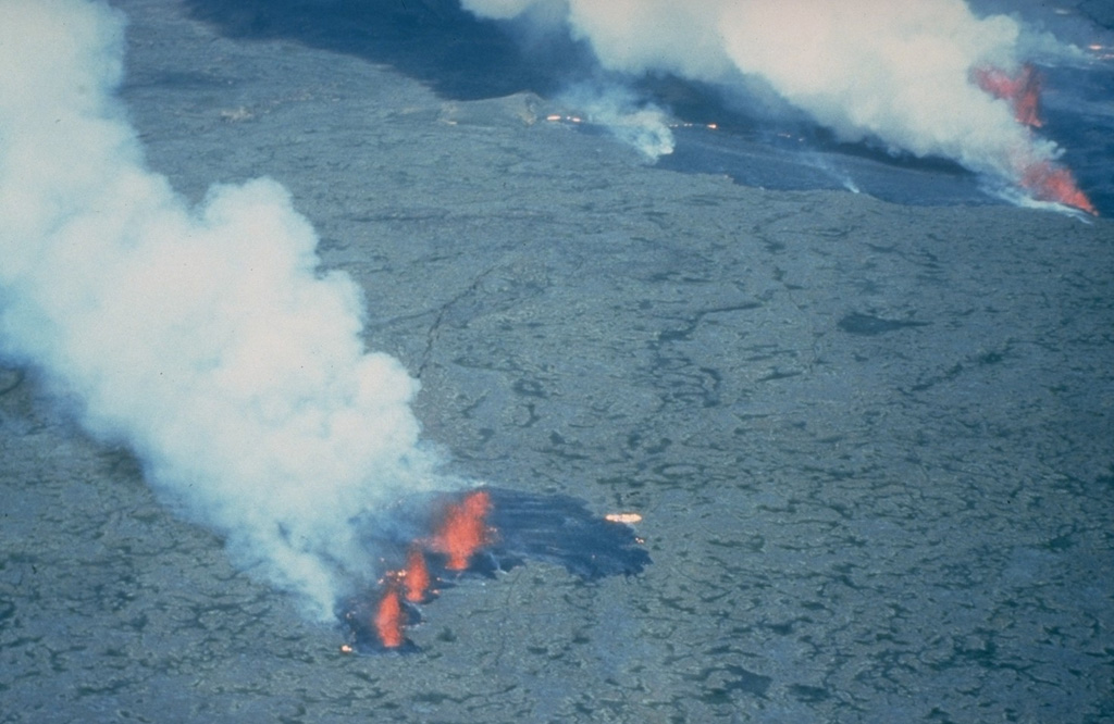
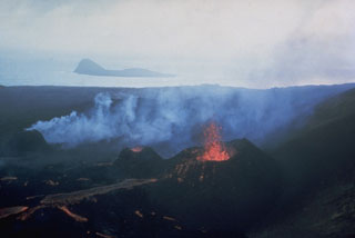
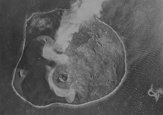
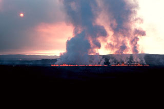 A steam plume rises above a line of small lava fountains on 5 September 1984, the day after the onset of an eruption from an 8.5-km-long fissure extending north from Leirhnjúkur. During the first hours of the eruption, the fissure was active along its entire length, producing a sheet of pahoehoe lava, but later activity was concentrated at a single vent near the northern end of the fissure. This fissure eruption was the last of a decade-long series of Krafla eruptions beginning in 1975 that accompanied an episode of crustal spreading.
Photo by Michael Ryan, 1984 (U.S. Geological Survey).
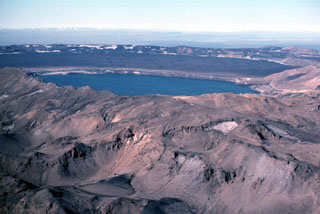 Askja is a central volcano made up of the Dyngjufjöll massif and at least three calderas, the largest of which is 8 km wide. This view from the SE looks across Öskjuvatn lake within the youngest caldera that formed in 1875 during Askja's largest historical eruption. It truncates a larger caldera, whose wall is seen in the distance above the lava-covered caldera floor. The 100-km-long Askja fissure swarm, which includes the Sveinagjá graben, is also related to the Askja volcanic system.
Photo by Michael Ryan, 1984 (U.S. Geological Survey).
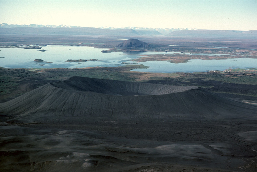
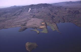
 Fremrinámar, NNE of Askja and SE of Mývatn lake, is a volcanic system that is constructed over the Ketildyngja shield volcano (center). Associated fissure systems, including the Sveinar fissure, extend 130 km to the N coast of Iceland. Mývatn lake formed as a result of the eruption of the 70-km-long older Laxarhraun lava flow from Ketildyngja shield volcano about 3,800 years ago. The latest eruption from Fremrinámar produced the Búrfellshraun lava flow about 2,500-3,000 years ago.
Photo by Richie Williams, 1981 (U.S. Geological Survey).
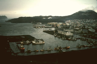 The harbor on the island of Heimaey is seen here in 1974, in the aftermath of an eruption that produced a lava flow that almost blocked the harbor entrance. The flow, which originated from a fissure extending from Eldfell cinder cone (upper right) forms the peninsula at the upper left. Extensive water pumping efforts were undertaken to cool and stop the advance of the flow; the diversion attempts were locally successful. The flow eventually stopped, after extending the shoreline up to 1.1 km over a 2.7-km-wide area, providing a more sheltered harbor.
Photo by Robin Holcomb, 1974 (courtesy of Jack Lockwood, U.S. Geological Survey).
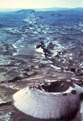
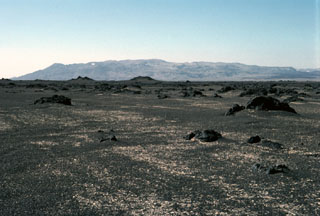
 The eastern rim of the summit crater of Ketildyngja shield volcano overlooks flat-lying lavas of the Fremrinamur volcanic system on the right and steep-sloped Pleistocene subglacial lavas on the left.
Photo by Michael Ryan, 1984 (U.S. Geological Survey).
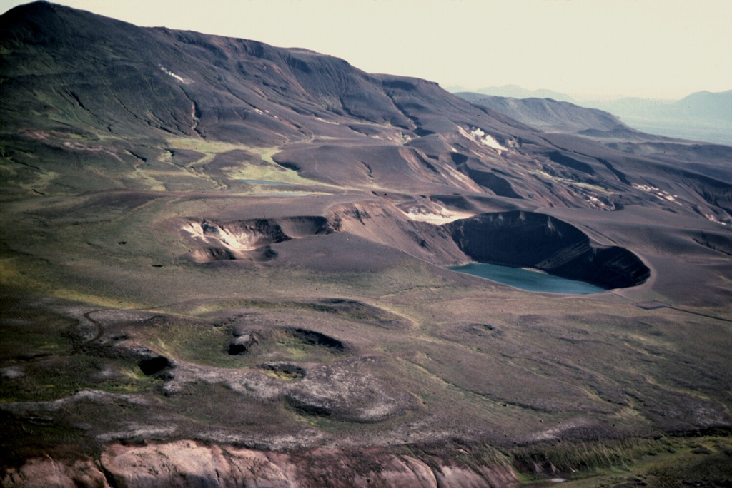
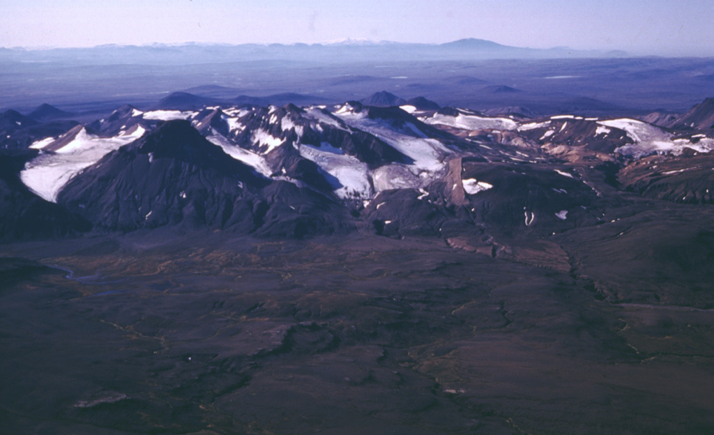
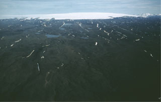
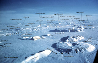 An aerial view from the north shows features of the Theistareykjabunga and Krafla volcanic systems. The low-relief Theistareykjabunga volcano, with the Stora-Viti and Litla-Viti summit craters, appears at the lower left. The topographically indistinct Krafla caldera (center) is cut by prominent fissure swarms. The flat, mesa-like areas at the right and other topographically prominent features throughout the photo are table mountains and ridges formed during Pleistocene subglacial eruptions.
Photo by Oddur Sigurdsson, 1977 (Icelandic National Energy Authority).
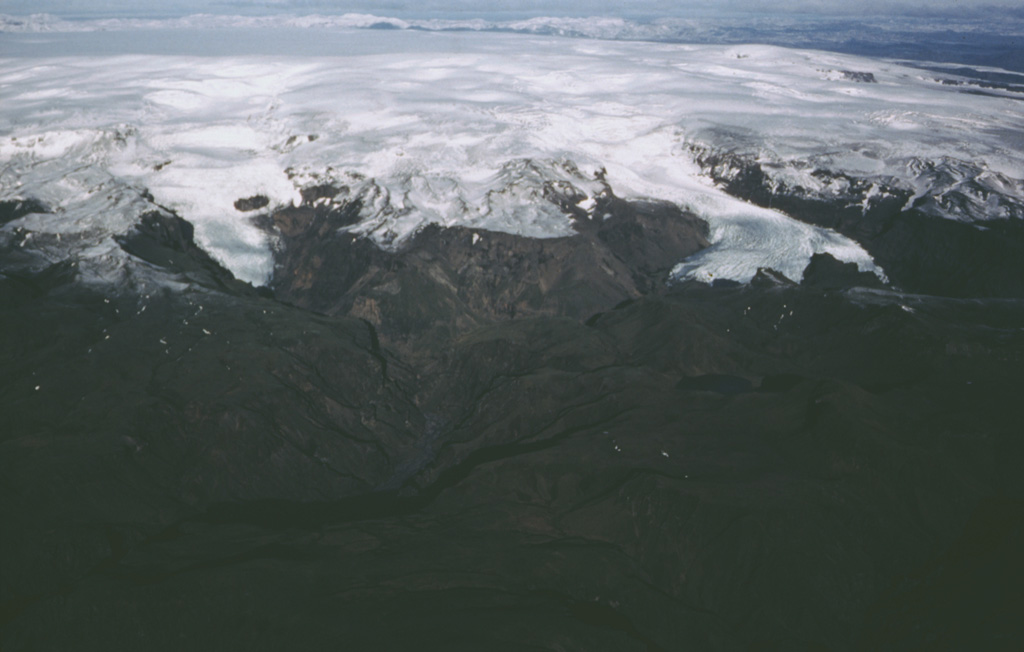
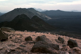
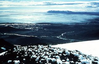 The broad, relatively flat-topped and ice-covered summit of the Kverkfjöll volcano (upper right) is seen here from Snæfell mountain. This view looks WSW across the Bruarjökull glacier, an outflow sheet of the vast Vatnajökull icecap. Holocene lavas form the dark ridge extending across the horizon to the right from Kverkfjöll.
Photo by Oddur Sigurdsson, 1978 (Icelandic National Energy Authority).
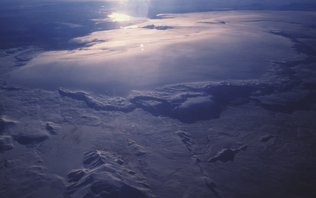
 Hveravellir central volcano occupies the northeast section of the massive Langjökull icecap, which is seen here in an aerial view from the north with Hvítárvatn lake on the opposite side reflecting the sun. A summit caldera lies beneath the ice. An approximately 100-km-long fissure system extends to the north and southwest of Hveravellir, with numerous small shield volcanoes and lava flows.
Photo by Oddur Sigurdsson, 1990 (Icelandic National Energy Authority).
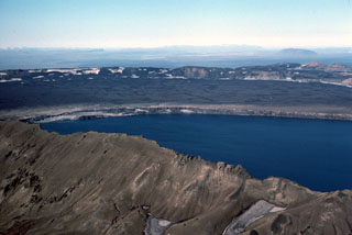 Askja's largest historical eruption occurred in 1875. Subsidence of the caldera continued for 40-50 years after the eruption and resulted in the formation of Askja's inner caldera, now filled by Öskjuvatn lake, seen here from the SE. The flat, lava-covered floor of the main caldera can be seen beyond the lake, encircled by the caldera rim.
 Photo by Michael Ryan, 1984 (U.S. Geological Survey).
 An aerial view from the NE shows the Hengill central shield volcano on the center horizon rising above Thingvallavatn lake. Steam rises from the Nesjavallavirkjun geothermal area in front of the peak. NE-trending fault scarps extend into the lake. Holocene fissure-fed eruptions have occurred from vents both northeast and southwest of the Hengill central volcano, with fissures extending into the lake. Just out of the bottom of the picture (north) is an island where phreatomagmatic activity created a tephra ring called Sandey about 1,900 years ago.
Photo by Oddur Sigurdsson, 1998 (Icelandic National Energy Authority).
 The most prominent of a series of fissures extending NE and SW from Grímsvötn central volcano is the noted Laki (Skaftár) fissure, which trends vertically across the photo SW of Grímsvötn and immediately SW of the Vatnajökull ice sheet. Laki produced the world's largest known historical lava flow during an eruption in 1783, as well as large volumes of gases but relatively little tephra. The approximately 27-km-long fissure is characterized by a sequence of craters and cones like that seen in the foreground.
Photo by Sigurdur Thorarinsson (courtesy of Richard Williams, U.S. Geological Survey).
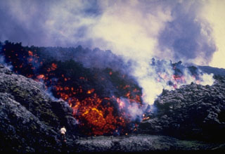 A volcanologist can be seen (bottom left) observing the incandescent front of a steaming, blocky lava flow that is advancing from Hekla volcano during a three-day eruption beginning on 17 August 1980. Lava issued from much of the 5.5-km-long fissure that runs along Hekla’s summit ridge, producing lava flows that covered much of the northern flanks and flows to the E, S, and SW.
Photo courtesy of Gudmundar Sigvaldason (Nordic Volcanological Institute), 1980.
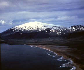 Glaciated Snæfellsjökull towers above Breiðavík bay at the western tip of the Snæfellsnes Peninsula in western Iceland. Numerous cones have formed across the flanks and Holocene lava flows extend across the entire western half of the edifice to the sea. One recent flow that reached the coast on the eastern flank can be seen in the left side of the photo.
Photo by Richie Williams, 1979 (U.S. Geological Survey).
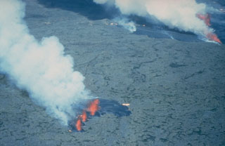
 Lava flows issue from three small spatter cones on the island of Surtsey on 27 August 1966. Eruptions began in November 1963 and soon formed a new island, with lava effusion starting in April 1964. Eruptions at Iceland's newest island continued until 1967. The small island of Jolnir in the background began growing 800 m SW at the end of October 1965. It went through repeated episodes of growth and destruction before it ceased activity on 10 August 1966 and was eroded away by October.
Photo by Richie Williams, 1966 (U.S. Geological Survey).
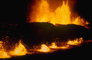
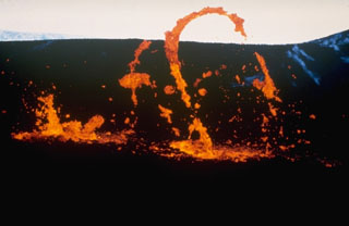 Ribbons of molten lava are thrown from a vent at Krafla volcano in October 1980 during a period of low-intensity activity. Four eruptive episodes occurred at Krafla during 1980. One of these, a brief episode of phreatic activity on 15 June, was explosive. The other three eruptive phases, in March, July, and October, were dominantly effusive.
Photo courtesy of Gudmundar Sigvaldason, 1980 (Nordic Volcanological Institute, Reykjavik).
 Lava fountains rise above an eruptive fissure cutting the snow-covered floor of Krafla caldera on 16 March 1980. This eruptive episode, the first of four during 1980, lasted only six hours. The fissure was active along a total length of 4.5 km, although the longest continually active segment was 800 m long. Most of the lava effusion took place during the first two hours. Eight separate lava flows were erupted, covering an area of 1.3 km2 to a depth of 2 m.
Photo courtesy of Gudmundar Sigvaldason, 1980 (Nordic Volcanological Institute, Reykjavík).
 The classic Icelandic shield volcano Skjaldbreiður, seen here from the W along Route 52, formed about 9,500 years ago during a long eruption in the southern part of the Oddnyjarhnjukur-Langjokull volcanic system in central Iceland. It produced 17 km3 of basaltic lava flows and is capped by a small 300-m-wide summit crater.
Photo by Richie Williams, 1981 (U.S. Geological Survey).
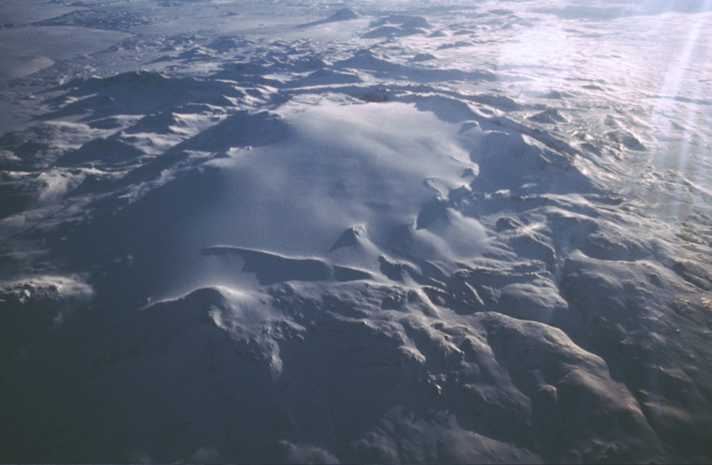
 The broad Hofsjökull volcano lies beneath the western part of the massive Hofsjökull icecap. A caldera 7-8 km wide is beneath about 700 m of ice to the right of the high point in this view from the NNW. Lava flows are found to the south, east, and north of this central volcano. The rugged ice-covered peak at top right is the Kerlingarfjöll edifice.
Photo by Oddur Sigurdsson, 1978 (Icelandic National Energy Authority).
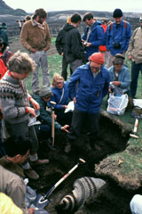 Icelandic volcanologist Sigurdur Thorarinsson (right center, with red cap) discusses ash layers exposed in an excavated pit with an international group of volcanologists on a field trip. Thorarinsson pioneered the technique of tephrochronology, and his detailed studies of tephra layers from Hekla demonstrated the value in determining the relative ages of ash layers by their stratigraphic position between dated horizons.
Photo by Bill Rose, 1980 (Michigan Technological University).
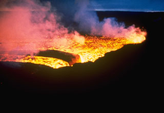
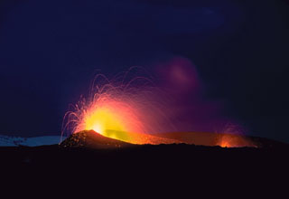
 The last phase of the 1980 Krafla eruption began on 18 October, after a three-month period of quiescence. By the second night of the eruption, photographed here, activity was concentrated along two parallel eruptive fissures. Powerful lava fountains rose above the background fissure. The fissure in the foreground was less active but contained an elongated lava pond above which a row of small lava fountains formed.
Photo courtesy of Gudmundar Sigvaldason, 1980 (Nordic Volcanological Institute, Reykjavik).
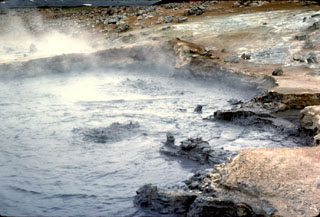 The Námafjall and Myvatn geothermal areas contains boiling mudpots such as these, numerous fumaroles, hot pools, and extensive areas of hydrothermally altered ground (the lighter-colored ground surface). Thermal activity keeps the ground warm enough in nearby areas so that there is no risk of frost at night. Farmers have taken advantage of this natural heat source to grow potatoes in an area of northern Iceland where that would normally not be possible.
Photo by Michael Ryan, 1984 (U.S. Geological Survey).
 The Askja central volcano, seen here from the north, forms the Dyngjufjöll massif about 20 km N of the Vatnajökull icecap. The massif is mainly composed of subglacial pillow lavas, lava flows, and hyaloclastites, with a broad summit truncated by three overlapping calderas. Much of the Holocene activity has been focused at and around this central massif, but the Askja volcanic system includes fissure swarms extending 170 km N.
Photo by Michael Ryan, 1984 (U.S. Geological Survey).
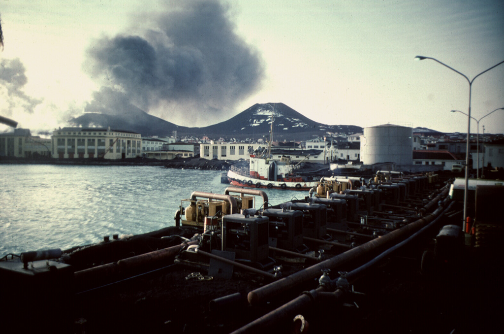
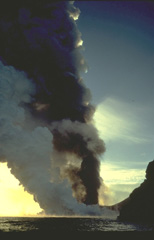 A thick column of steam rises above a lava flow that is entering the sea along the coast of Heimaey Island in January 1973. The lava flow reached the sea during the first day of the eruption. Concern that the flow would seal off the island's only harbor prompted the evacuation of all but essential personnel from the island. Nearly all of the island's 5000 residents were evacuated the first night of the eruption.
Copyrighted photo by Katia and Maurice Krafft, 1973.
 One spectacular feature of the July 1980 eruption at Krafla was the cascading of a 200-m-wide lava flow into an open preexisting fissure. Lava flowed into the fissure for several hours without filling it.
Photo courtesy of Gudmundar Sigvaldason, 1980 (Nordic Volcanological Institute, Reykjavik).
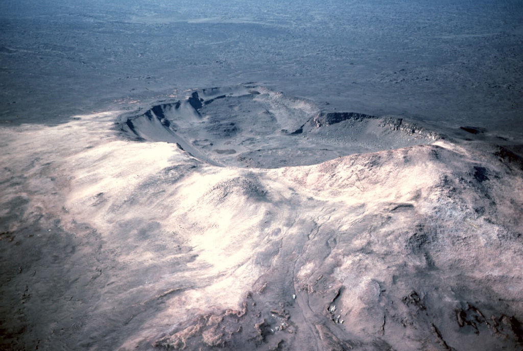
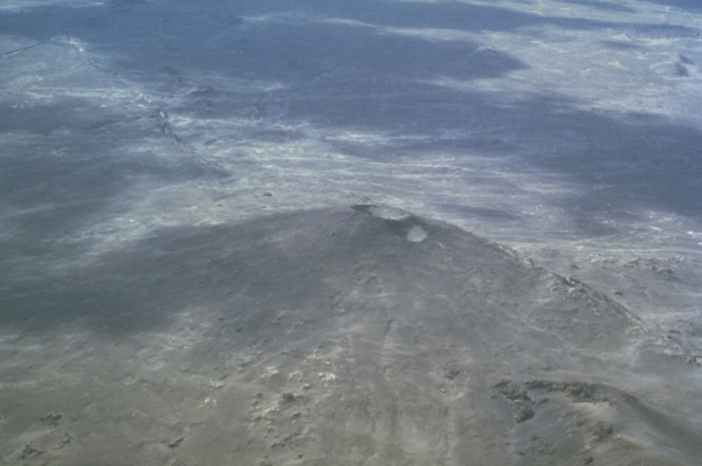
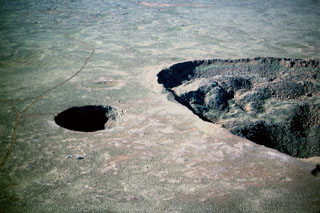 The small Litlavíti pit crater (left) lies immediately SSW of Stóravíti crater (right) near the summit of the Theistareykjarbunga shield volcano. The very low-angle volcano is part of Theistareykir, the northernmost subaerial volcanic system of Iceland's Eastern Volcanic Zone.
Photo by Michael Ryan, 1984 (U.S. Geological Survey).
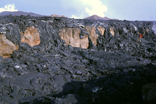 Fresh black pahoehoe lava flows from the 1984 eruption of Krafla drape the Gjastikki fault, whose escarpment forms the brownish cliff surfaces. Note the geologist at the upper right for scale (with red backpack). The still-steaming lava flow, photographed here on 7 September, is only days old and partially buries the fault, which was produced during a previous rifting episode. The steaming cones in the background indicate the location of the vents.
Photo by Michael Ryan, 1984 (U.S. Geological Survey).
 Strombolian eruptions from two vents on a fissure on the northern flank of Hekla volcano in May 1970. Three areas were active in 1970, producing lava flows to the N, W and SW. The Oldugigar vent (erupting in the foreground) and the nearby Hlidagigar vent were the source of the most voluminous lava flows of the 1970 eruption. The lava flows traveled 6 km N over uninhabited land.
Photo by Robert Citron, 1970 (Smithsonian Institution; courtesy of William Melson)
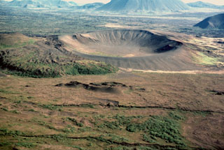 The Ludent tuff ring, seen here from the west, formed in a phreatomagmatic eruption in the early Holocene. The Ludentsborgir crater row in the foreground formed during an eruption about 2,200 years ago which produced the massive lava flows that entered Mývatn lake and traveled about 60 km, reaching the northern coast of Iceland.
Photo by Michael Ryan, 1984 (U.S. Geological Survey).
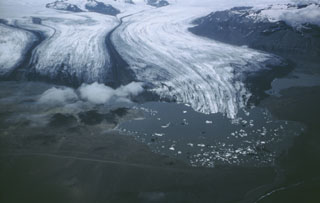 The subglacial Esjufjöll volcano rises (upper left) above the Breidamerkurjökull glacier, with its prominent medial moraines. Icebergs calved from the glacier can be seen floating in Jökulsárlón lake, which drains into the Atlantic Ocean (extreme lower right). Esjufjöll is located at the SE part of the Vatnajökull icecap, north of Öræfajökull volcano.
Photo by Oddur Sigurdsson, 1986 (Icelandic National Energy Authority).
 The island of Surtsey, seen here from the NW, developed during an eruption from 1963 to 1967 CE. This 1966 photo shows an active eruption from the floor of the Surtur cone (top), with a small steam plume towards the SE and fresh dark lavas on the eastern side of the island (top). The circular Surtungur vent (bottom cone), and its contiguous lava shield to the south were formed in 1964-65 during a period of lava effusion.
Photo by Icelandic Survey Department, 1966 (published in Green and Short, 1971).
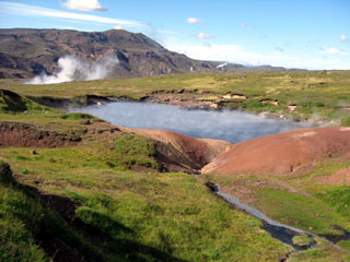 Steam rises from a hot pool in the Olkeduháls geothermal area of the Hrómundartindur volcanic system, which lies south of Thingvallavatn lake. The geothermal field contains numerous hot springs, mud pools and fumaroles. Steam plumes are visible at three locations in the background. The Hengill volcanic system forms the ridge on the skyline immediately west of the Hrómundartindur system.
Photo by Lee Siebert, 2008 (Smithsonian Institution).
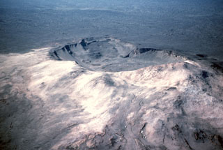 The elongate Ketildyngja shield volcano, the most prominent feature of the Fremrinámur volcanic system, formed about 4,000 years ago and contains a distinct summit crater of about 400 x 800 m. Associated fissure systems extend from just northwest of Askja, across the Ketildyngja shield, and about 130 km to the northern coast of Iceland.
Photo by Michael Ryan, 1984 (U.S. Geological Survey).
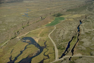 An aerial perspective of Thingvellir, the site of Iceland's historical outdoor parliament, shows the NE-SW-trending Almannagjá fissure cutting diagonally across the left side of the photo. Other prominent fissures cutting lavas of the Hengill volcanic system appear at the right. The Logberg, or law-hill (located at the lower left below the 30-40 m high Almannagja fissure) was the site where the laws of the country were proclaimed during the annual two-week-long parliamentary session in late June and early July.
Copyrighted photo by Katia and Maurice Krafft.
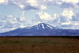 Hekla has a conical profile when viewed from the SW, looking directly down the axis of the elongated volcano. Axlargigur, the WSW end of the 5.5-km-long Heklugja fissure that crosses the summit, extends toward the photographer. This fissure was active along its entire length during the 1970 eruption.
Photo by Bill Rose, 1980 (Michigan Technological University).
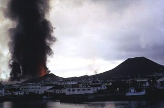 A dark ash column rises above lava fountains from a fissure eruption on the island of Heimaey in 1973. This explosive activity produced the Eldfell cinder cone (left), followed by effusion of lava flows which threatened the town of Vestmannaeyjar (foreground). Helgafell cone, on the right, formed during an eruption 5,900 years ago.
Photo by Tom Simkin, 1973 (Smithsonian Institution).
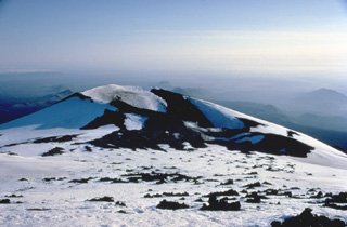 Axlargigur, at the SW end of Hekla's summit ridge, was one of the principal vents during a major eruption in 1947. The initial plinian phase of the eruption began on March 29, 1947, and produced a towering ash column that reached a height of 30 km. Tephra fall occurred primarily to the south, and ashfall reached the Finnish-Russian border. Lava flows from a 5-km-long fissure along the summit ridge covered 40 km2, primarily on the eastern, southern, and western sides of the volcano.
 Copyrighted photo by Katia and Maurice Krafft.
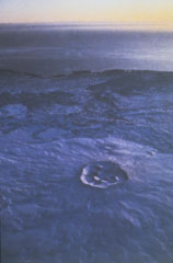 The Reykjanes volcanic system at the SW tip of the Reykjanes Peninsula in Iceland comprises a broad area of postglacial crater rows and small shield volcanoes. Snow-covered Sandfellshæd shield volcano (lower center), capped by a small crater of approximately 400 m diameter, rises less than 100 m above the Atlantic Ocean to the south (background). Most of the volcanic system is covered by Holocene lava flows. Eruptions have occurred in historical time. Eruptions during the 13th century distributed tephra across the Reykjanes peninsula and lava covered about 50 km2.
 Photo by Helgi Torfason (courtesy of Richie Williams, U S Geological Survey, published in Gudmundsson, 1986).
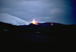 On 5 May 1970 fissures opened on the SSW, W, and NNE flanks of Hekla. An eruption plume reached nearly 16 km high, and fountaining fed lava flows to the SW, WNW, and N. Two eruptive fissures were active on the NE flank, seen here with minor Strombolian activity; these produced lava flows that traveled 6 km N. The N-flank lava flow remained active until 5 July.
Photo by Robert Citron, 1970 (Smithsonian Institution; courtesy of William Melson)
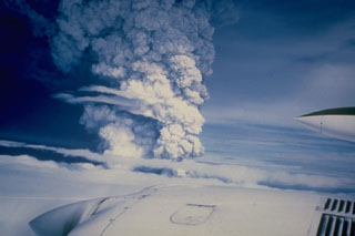 An eruption column is seen rising above a cloud layer over Hekla volcano on 17 August 1980. The eruption began with a Plinian phase producing this 15-km-high eruption column. Lava flows were simultaneously produced along the fissure that runs along the Hekla edifice. During the next three days, lava flows issued from nearly the full length of the fissure and produced six flows, primarily on the northern side of the summit ridge. One lava flow travelled about 8 km to the SW.
Photo courtesy of Gudmundar Sigvaldason (Nordic Volcanological Institute), 1980.
 The small Grímsnes volcanic field is seen here in an aerial view from the southwest. A major road (Route 35) is seen running from the top to the bottom of the picture. To the east of this is the Tjarnarhólar crater row (bottom right), including the lake-filled Kerid Crater at the top. The Seyðishólar and Kerhóll cinder cones visible at top center formed about 9,500 and 7,050 years ago, respectively.
Photo by Oddur Sigurdsson, 1991 (Icelandic National Energy Authority).
 An April 1968 vertical aerial photo shows the ~2-km-wide island of Surtsey, less than one year after eruptive activity ceased. This island was formed during eruptions from November 1963 until June 1967 CE. Initial submarine eruptions rapidly produced a new island that became permanent after lava effusion began in 1964. The remains of two cinder cones and associated craters can be seen in the northeast (top) of the island. Several other ephemeral islands around Surtsey that were not armored by lava are now eroded beneath the ocean surface.
Photo by National Aeronautical and Space Administration (NASA), 1968.
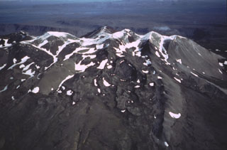 The Ljósufjöll volcanic system at the eastern end of the Snæfellsnes Peninsula is contains a group of scoria cones and lava flows along a roughly 90-km-long WNW-ESE trend. The crest of the Ljósufjöll range is seen here from the south with glacial moraines descending the flanks.
Photo by Oddur Sigurdsson, 1983 (Icelandic National Energy Authority).
 The Búðaklettur scoria cone on the east flank of Snæfellsjökull in western Iceland was the source of the Búðahraun lava flow covering 18 km2 and forming a peninsula. Holocene lava flows form much of the surrounding coastline.
Photo by Richie Williams, 1981 (U.S. Geological Survey).
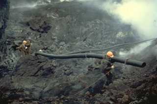 Workers carry pipes used during a massive attempt to cool the advancing lava flow produced by the 1973 eruption of Heimaey volcano. Water was pumped beginning on February 6, initially using a single large pump, and then larger pumps flown in from Iceland and the United States. On March 1, a pumping vessel arrived that sprayed water from the harbor. Cooling locally produced solidified barriers that diverted and stopped the lava flow. The lava flow created new land when it entered the sea and eventually improved the island's only harbor.
Copyrighted photo by Katia and Maurice Krafft, 1973.
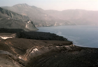 The dark Batshraun lava flow descending from the left into Öskjuvatn lake was erupted during 1921. The lava flow originated from a vent below the NE rim of Askja's central caldera, and flowed over the low rim of the younger 1875 caldera into the lake. The lava flow was the first of several during the 1920's that flowed into the NE, SE, and W sides of Öskjuvatn lake.
Photo by Michael Ryan, 1984 (U.S. Geological Survey).
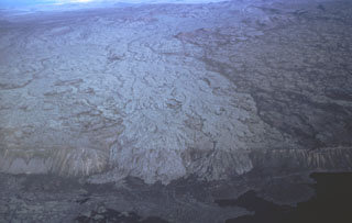 The Brennisteinsfjöll volcanic system, located east of Kleifarvatn lake, consists of a 45-50 km long NE-SW trending fissure swarm, with crater rows and small shield volcanoes. Brennisteinsfjöll is seen here in an aerial view from the south with light-colored lava flows spilling over a 100 m high E-W-trending scarp from vents at least 8 km to the north. The body of water seen bottom left is the Hliðarvatn lake.
Photo by Oddur Sigurdsson, 1983 (Icelandic National Energy Authority).
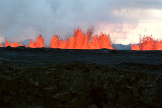 Incandescent lava fountains rise from an eruptive fissure at Krafla volcano in NE Iceland on 6 September 1984. After a quiet interval of 33 months, an eruption began on 4 September along a fissure extending from Leirhnjúkur 8.5 km N. Initially, the fissure was active along its entire length, but later lava production was highest at the northern end.
Photo by Michael Ryan, 1984 (U.S. Geological Survey).
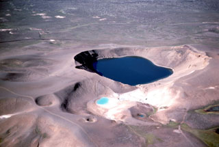 An explosive eruption in 1724 during which the 350-m-diameter Viti Crater and 14 other smaller craters formed marked the start of a five-year-long period of rifting and eruptions known as the "Myvatn Fires." Viti and neighboring smaller craters, seen here from the east, were formed during a brief eruption on 17-18 May 1724. The eruption and accompanying earthquakes caused people living on farms east of Myvatn lake to flee.
Photo by Michael Ryan, 1984 (U.S. Geological Survey).
 The Krafla central volcano, located NE of Mývatn lake, is a topographically indistinct 9-km-wide caldera that is cut by a N-S-trending fissure system. This view from the south looks toward the center of the caldera with the rhyolitic lava dome of Hlidarfjall on the left and prominent fissures cutting across the caldera at the right.
 Photo by Michael Ryan, 1984 (U.S. Geological Survey).
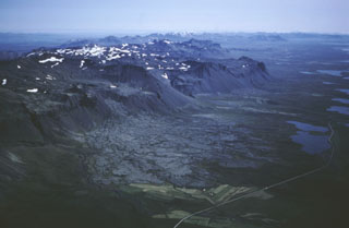 An aerial view looking east down the Snæfellsnes Peninsula shows the Bláfeldarhraun lava flow in the foreground. The cone that produced it is part of the Helgrindur (Lýsuskarð) volcanic system, which consists of small scoria cones and vents along a WNW-ESE trend across the central Snæfellsnes Peninsula.
Photo by Oddur Sigurdsson, 1983 (Icelandic National Energy Authority).
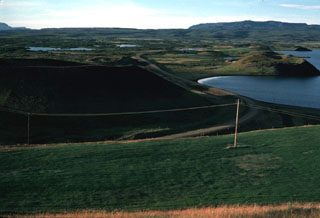 The Laxarhraun lava field in the Heiðarspordar volcanic system covered much of the Lake Mývatn area and lava flowed down the Laxardalur canyon to the north coast. Numerous pseudocraters and rootless cones, some of which are seen here along the shore of the lake, formed as a result of secondary explosive activity when the lava flow encountered abundant groundwater. The massive 224 km2 flow, erupted about 2,000 years ago, forms all but the northern shoreline of the lake.
Photo by Michael Ryan, 1984 (U.S. Geological Survey).
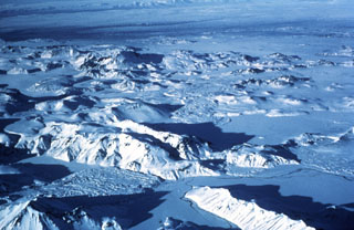 The Torfajökull central volcano is cut by a 12 x 18 km caldera that formed during the Pleistocene. Torfajökull is of one of the largest areas of silicic and intermediate volcanism in Iceland. The Laugahraun (lower left) and Domadalshraun (right center) lava flows, seen here from the SE, are located just within and north of, respectively, the northern caldera rim. At least 12 eruptions have occurred in the last 9,000 years with activity concentrated in the west.
Photo by Oddur Sigurdsson, 1977 (Icelandic National Energy Authority).
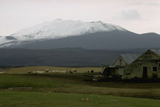 The Hekla edifice, seen here from the east, is elongated due to repeated eruptions along an ENE-WSW fissure that runs across the edifice. Numerous eruptions are recorded throughout the Holocene, both along this summit fissure system and from vents and fissures on the flanks.
Photo by Robert Citron, 1970 (Smithsonian Institution; courtesy of William Melson)
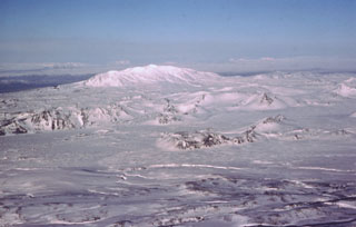 The Vatnafjöll volcanic system, seen as the rugged landscape cutting across the center of the image, is a 60-km-long, 9-km-wide chain of alkali basaltic fissures and crater rows located south of the more prominent Hekla volcano (center horizon). The elongate profile of Hekla is due to the presence of an elongate eruptive fissure parallel with the ridge, which has been the site of numerous Holocene eruptions. The Vatnafjöll fissure swarm is less frequently active than the Hekla edifice, but they are considered as part of the same volcanic system. About 50 Holocene lava flows are identified from the Vatnafjöll fissures, most recently about 1,200 years ago.
Photo by Oddur Sigurdsson, 1977 (Icelandic National Energy Authority).
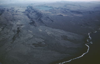 The Krýsuvík-Trölladyngja volcanic system consists of NE-SW-trending crater rows and small shield volcanoes cutting the central Reykjanes Peninsula west of Kleifarvatn lake (top center). Several eruptions have taken place since the settlement of Iceland, including the emplacement of a large lava flow from the Ogmundargigar crater row around the 12th century. The lava flow was confined to the valley between the two parallel ridges (top left), before reaching the southern coast of the Reykjanes Peninsula (lower right) along a broad front.
Photo by Oddur Sigurdsson, 1983 (Icelandic National Energy Authority).
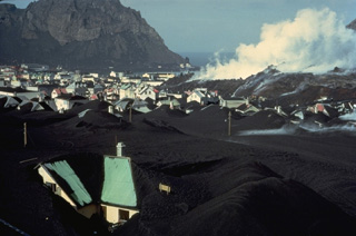 A steaming lava flow advances through the town of Vestmannaeyjar in April 1973. Houses in the foreground are partly buried by thick ashfall deposits from the Eldfell cinder cone, which began erupting on January 23. The lava flow advanced into the town's harbor, which lies between the flow and the cliff at the upper left. The flow covered a 300-m-wide, 700-m-long area in the NE part of town, burying 200 houses and buildings during a two-week period of extrusion in late March and early April.
Copyrighted photo by Katia and Maurice Krafft, 1973.
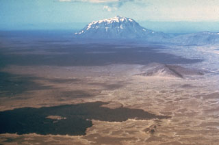 The dark Vikrahraun lava flow in the foreground was erupted from the NE side of Askja caldera in 1961. The flat-topped mountain in the distance to the NE is Herdubreid, the most famous of Iceland's "table mountains." These steep-sided mountains were formed by repeated eruptions during the Pleistocene through the glacial icecap. The subglacial lava flows and fragmental hyaloclastite rocks ponded against the melted walls of the glacier. Only at the last stage were minor subaerial lavas erupted above the icecap, forming the small summit peak.
Photo by Richie Williams, 1973 (U.S. Geological Survey).
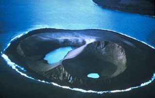 Water was present in two craters on Jolnir Island on 22 August 1966, less than two weeks after it ceased erupting. Jolnir was formed during repeated submarine eruptions that began in October 1965, immediately SW of the new island of Surtsey (upper right), rising above sea level and then being destroyed by erosion multiple times before it ceased activity on 10 August. No lava flows were produced, and a month after this photo was taken the loosely consolidated ash deposits that formed the island were eroded away.
Photo by Richie Williams, 1966 (U.S. Geological Survey).
 The broad shield volcano Skjaldbreiður (seen here) rises about 500 m above its surroundings, and has an approximately 300-m-wide summit crater. This volcano formed within the southern part of the Oddnyjarhnjukur-Langjokull volcanic system, between Thorsjökull glacier and Thingvallavatn lake, during the first half of the Holocene.
Photo by Ingibjörg Kaldal (Orkustofunun, courtesy of Richie Williams, U.S. Geological Survey).
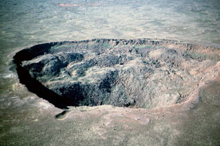 Stóravíti crater, seen here from the SE, is 600 m across and 140 m deep. It is located in the summit area of the Holocene Theistareykjarbunga shield volcano, part of the northernmost subaerial volcanic system along the Eastern Volcanic Zone of Iceland. The youngest dated eruption in this system produced the Theistareykjahraun lava flow about 2,400 years ago.
Photo by Michael Ryan, 1984 (U.S. Geological Survey).
 The Bláfeldarhraun lava flow front is seen to the left of the farmhouses. It originated from the cone to the upper left and descended the slope in the center of this view from the south. The flow is one of several Holocene lava flows of the Helgrindur (Lýsuskarð) volcanic system on the Snæfellsnes Peninsula.
 Photo by Lee Siebert, 2008 (Smithsonian Institution).
 The island of Heimaey, about 10 km off the south coast of Iceland, is part of the Vestmannaeyjar volcanic system, which comprises numerous islands and submarine vents. Heimaey probably formed in the Holocene, through numerous eruptions. Here, an ash-laden eruption plume rises above a volcanic cone behind the town of Vestmannaeyjar in 1973. The water pumping operation in the foreground was designed to cool the front of an advancing lava flow that threatened the town and its harbor.
Photo by Jack Lockwood, 1973 (U.S. Geological Survey).
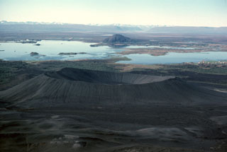 The Hverfjall tuff ring (foreground) developed during phreatomagmatic explosions at the southern end of a 23-km-long fissure. This tuff ring is the largest of the Krafla volcanic system, with a crater about 1 km wide. Lava-dammed Mývatn lake, in the background to the west, provides wildlife habitat and is renowned for its diversity of bird life. The lake has formed on lava flows from nearby Heiðarsporðar volcano, which surround Vindbelgjarfjall, the dome seen on the far side of the lake.
Photo by Michael Ryan, 1984 (U.S. Geological Survey).
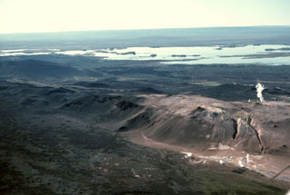 The Námafjall hyaloclastic ridge, formed as a result of subglacial eruptions, cuts diagonally across the foreground of the photo, with Mývatn lake in the middle distance to the SW. The discoloration of the ground on and around the ridge is due to the geothermal activity causing alteration in the rocks. Steam plumes can be seen both in front and behind the ridge from geothermal sites. The site in the foreground at the bottom of the ridge is Hverir, a geothermal tourist attraction.
Photo by Michael Ryan, 1984 (U.S. Geological Survey).
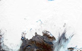 Þórðarhyrna (Thordarhyrna) is below the Vatnajökull glacier with the ice between 100-600 m thick, shown in this 29 October 2019 Sentinel-2 satellite image (N is at the top; this image is approximately 52 km across). The edifice is 15 km in diameter and is part of the Grímsvötn volcanic system. Cauldrons that have formed within the ice above indicate geothermal activity.
Satellite image courtesy of Copernicus Sentinel Data, 2019.
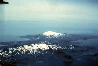 Lýsuhóll, Iceland's smallest volcanic system, consists of small scoria cones and vents in a roughly NW-SE trend along the Snæfellsnes Peninsula in the center of this photo. The cones and vents are seen here from the ENE and are located between the snow-covered Helgrindur mountains in the foreground and the glaciated Snæfellsjökull in the background.
 Photo by Thorvaldur Bragason, Iceland Geodetic Survey (courtesy of Richie Williams, U.S. Geological Survey).
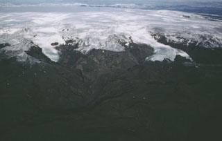 Katla volcano, near the southern end of Iceland's Eastern Volcanic Zone, comprises a central volcano, a 100 km2 caldera beneath the Mýrdalsjökull icecap, plus fissure systems. Valley glaciers descend from the summit toward the coastal plain in this aerial view from the SSW. Katla has very frequent eruptions. Explosive eruptions from the central volcano produce large volumes of tephra and are frequently accompanied by damaging glacier-outburst floods called jökulhlaups. Effusive eruptions producing large volumes of lava are characteristic of the fissure system.
Photo by Oddur Sigurdsson, 1985 (Icelandic National Energy Authority).
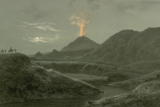 The 1845 eruption of Hekla volcano is depicted in this sketch as seen from Selsund, SW of the volcano. Tephra from the eruption, which began on September 2, was carried to the ESE. Locally, the fluorine-rich ashfall took a large toll on livestock, and fine ash fell as far away as the Faroe, Shetland, and Orkney islands. Lava flows covered about 25 km2 and moved mainly to the west and NW. The eruption lasted for seven months.
From the collection of Maurice and Katia Krafft.
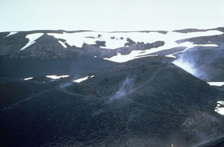 Steam rises in 1967 from a scoria cone along the Vikraborgir crater row, which was formed during an eruption of Askja volcano in 1961. The eruption began on 26 October from a fissure cutting the NE caldera floor. A chain of small scoria cones formed over the eruptive fissure, which fed lava flows that traveled 9.5 km E.
Photo by Richie Williams, 1967 (U.S. Geological Survey).
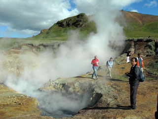 A group of volcanologists on a field trip observe activity at the Olkeduháls geothermal field of the Hrómundartindur volcanic system. The latest eruption at Hrómundartindur occurred about 11,000 years ago, from a vent about 1 km N of this geothermal field. The eruption produced a small lava flow, which reached about 4-5 km from the vent and covered about 4 km2.
Photo by Lee Siebert, 2008 (Smithsonian Institution).
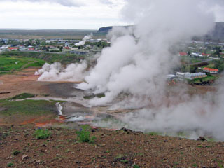 Steam plumes, newly formed after a May 2008 earthquake, rise from the Reykir ("smokes" in Icelandic) geothermal area, with the town of Hveragerdi in the background. The Hveragerdi geothermal field lies within the small Pleistocene Grensdalur volcanic system, the oldest of three volcanic systems in the Hengill area. The geothermal field include fumaroles, hot springs and pools, mud pots, and geysers, and provides heat to the town of Hveragerdi.
Photo coutesy of the University of Iceland Hvergerdi Research Station, 2008.
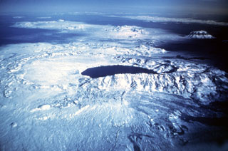 Askja, seen here in an aerial view from the south, is a large central volcano truncated by three overlapping calderas. The youngest caldera, formed during the large 1875 eruption, is filled by Öskjuvatn lake (center). This caldera partially truncates the largest Askja caldera, whose floor forms the flat-surfaced area left of the lake now filled with recent lava. The prominent snow-capped peak on the right is Herðubreið, which has not been active in the Holocene.
Photo by Oddur Sigurdsson, 1977 (Icelandic National Energy Authority).
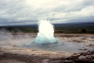 Iceland's largest geysers are located in the Haukadalur basin, part of the Geysir volcanic system, just east of the southern end of the Oddnyjarhnjukur-Langjokull fissure system. Here, the Strokkur geyser can be seen just as a burst of boiling water and steam erupts from a pool. This geyser erupts about every 10 minutes, producing a short-lived fountain that usually reaches about 20 m.
Photo by Bill Rose, 1975 (Michigan Technological University).
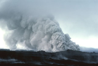 On 13 September 1984 groundwater gained access to the eruptive fissure at Krafla, producing these clouds of steam and ash. The two-week eruption, which began on 4 September 1984, was dominantly effusive, and produced 0.12 km3 of lava flows from an 8.5-km-long fissure.
Photo by Michael Ryan, 1984 (U.S. Geological Survey).
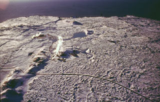 The submarine Reykjaneshryggur volcanic system, lying off the southwest tip of Iceland, is part of the Mid-Atlantic Ridge, which extends onto the Reykjanes Peninsula (foreground). A small plume of steam from geothermal activity is visible (middle left). Numerous submarine eruptions at Reykjaneshryggur dating back to the 13th century have been observed, some of which have formed short-lived islands. Submarine eruptions have been characterized by phreatomagmatic or Surtseyan explosive activity, depositing tephra on land. Subaerial eruptions have been typified by effusive activity, producing lava flows on Reykjanes Peninsula.
 Photo by Oddur Sigurdsson, 1998 (Icelandic National Energy Authority).
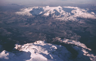 The broad massif of Tindfjallajökull is seen here from the ESE looking into the open 5 x 7 km summit caldera, with a rugged two-peaked rhyolitic dome in the center. The NW rim of the caldera is overtopped by the Tindfjallajökull icecap, which forms the smooth flat surface at the summit. Several small effusive eruptions occurred at the beginning of the Holocene.
Photo by Oddur Sigurdsson, 1976 (Icelandic National Energy Authority).
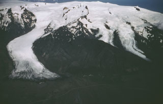 Öræfajökull is located near the SE coast of Iceland, viewed here from the west, with the Svinafellsjökull glacier (left) descending from the central icecap nearly to the coastal road. A subglacial caldera, 4 x 5 km, truncates the summit. Large eruptions in 1362 and 1727-28 were accompanied by jökulhlaups (glacier outburst floods) that caused property damage and fatalities.
 Photo by Oddur Sigurdsson, 1986 (Icelandic National Energy Authority).
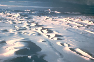 The Veidivötn fissure system, which extends about 100 km SW from Bárdarbunga volcano, has been the source of major eruptions during the Holocene. The approximately 60-km-long Vatnaöldur crater row, seen stretching across this image, formed during a major eruption on the southern part of the fissure system in about 877 CE. The explosive eruption produced large volumes of tephra and small lava flows. The peak on the center horizon is Hekla volcano.
Photo by Ingibjörg Kaldal (Icelandic National Energy Authority).
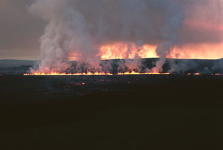 Lava fountains erupting along a fissure at Iceland's Krafla volcano early in the morning on 5 September 1984. A gas plume is visible along the length of the fissure. During the first hours of the eruption, which began just before midnight on the 4th, two eruptive fissures joined to become active along a total length of 8.5 km.
Photo by Michael Ryan, 1984 (U.S. Geological Survey).
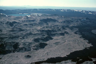 The dark-colored lava flow at the lower right was erupted during 1961 from a vent on the NE side of Askja caldera and flowed about 9.5 km E. The western rim of the ~8-km-diameter main Askja caldera can be seen in the background, rising above its flat, lava-covered floor. The 1961 vents were on the right in this image. The lake at the upper left is Öskjuvatn, which fills Askja's youngest caldera, formed due to the explosive 1875 eruption. The irregular slopes of the Dyngjufjöll massif in the foreground are formed almost entirely by the products of subglacial eruptions.
Photo by Michael Ryan, 1984 (U.S. Geological Survey).
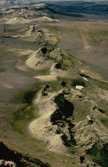 The most prominent of a series of fissures extending from Grímsvötn central volcano is the noted Laki (Skaftár) fissure, seen here, which trends to the SW. It produced the world's largest known historical lava flow during an eruption in 1783. Grímsvötn, Iceland's most frequently active volcano during historical time, lies largely beneath the vast Vatnajökull icecap. The caldera lake is covered by a 200-m-thick ice shelf, and only the southern rim of the 6 x 8 km caldera is exposed.
 Copyrighted photo by Katia and Maurice Krafft, 1975.
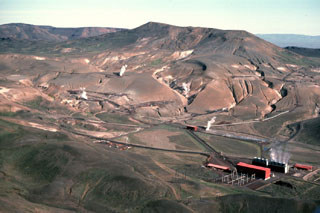 This power plant (lower right) is part of a large geothermal development south of the Krafla caldera. The Krafla ridge in the background is seen from the SW, with steam rising from the geothermal wells. The northeastern caldera rim forms the horizon on the left.
Photo by Michael Ryan, 1984 (U.S. Geological Survey).
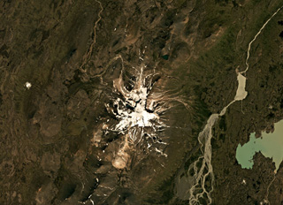 Snæfell (Snaefell) is comprised of a main edifice with NE-SW-trending fissures extending out to 10-18 km, with the former shown in this August 2019 Planet Labs satellite image monthly mosaic (N is at the top; this image is approximately 21 km across). An ice cap across the summit reaches a few tens of meters thick.
Satellite image courtesy of Planet Labs Inc., 2019 (https://www.planet.com/).
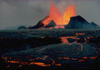 Lava fountains feed an incandescent lava flow at Krafla in September 1984. The eruption began on September 4, following a quiet interval of 33 months, from fissures extending 8.5 km north from Leirhnjukúr. Lava production was highest at the northern end of the fissure. The eruption lasted until September 18, and marked the end of an intermittent eruptive episode at Krafla that began in 1975.
 Copyrighted photo by Katia and Maurice Krafft, 1984.
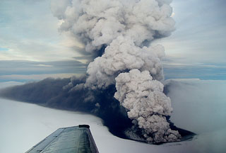 An ash plume rises from a new crater near the southern margin of Grímsvötn caldera in November 2004. Grímsvötn lies largely beneath the vast Vatnajökull icecap and the eruption melted its way through ice about 200 m thick. The plume extends towards the north due to the wind direction, coating the surface of the glacier in dark ash.
Photo by Freysteinn Sigmundsson, 2004 (Nordic Volcanological Center).
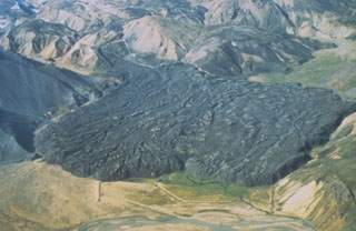 The viscous Laugahraun lava flow was emplaced in 1477 CE just inside the northern rim of Torfajökull caldera. This thick flow extends for about 2 km, and at its widest (left to right in this image), is about 1.3 km. Other small lava flows were produced at the same time as the Laugahraun lava flow: the Námshraun and Norðumámshraun lavas to the northeast just outside the caldera rim, and the Frostastaðahraun further north on the fissure system. The light-colored deposits surrounding the darker lava flow are rhyolitic volcanics.
Photo by Richie Williams, 1981 (U.S. Geological Survey).
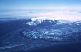 Kverkfjöll, seen here from the north, is a subglacial volcano at the northern end of the Vatnajökull icecap, west of Bárdarbunga. The Dyngjujökull glacier, an outflow sheet of the Vatnajökull icecap, appears in the foreground during a 1977 glacial surge. The dark ridge on the left, seen here separated from the outflow sheet by a stream, is a lava flow from about 4,500 to 6,100 years ago.
 Photo by Oddur Sigurdsson, 1977 (Icelandic National Energy Authority).
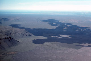 The dark lava flow field of the 1975-1984 rifting episode of Krafla extends about 16 km N into the distance, and reached the base of the eastern Gæsafjöll cliffs (left). One of Iceland’s table mountains, Gæsafjöll formed as a result of repeated eruptions through a glacial icecap.
Photo by Michael Ryan, 1984 (U.S. Geological Survey).
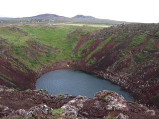 A small pond about 60 x 100 m fills the bottom of the Kerid crater at the northern end of the Tjarnarhólar crater row in the Grímsnes volcanic system. The crater is elliptical in shape, 180 x 280 m. The Seyðishólar and Kerhóll cinder cones, visible in the background to the north, were active about 9,500 and 7,050 years ago respectively. Seyðishólar is the only Holocene eruption recognized to have had tephra dispersal outside of the volcanic field.
Photo by Lee Siebert, 2008 (Smithsonian Institution).
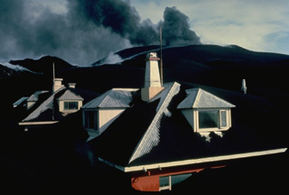 Eldfell cinder cone spews ash in the distance above the town of Vestmannaeyjar in April 1973. Thick ashfall deposits from the the volcano buried houses in the town. Most of the 5000 residents of the island were evacuated during the initial night of the eruption, which began on January 23. By the time the eruption ended on June 28, the volcano had ejected 0.02 cu km of ash, most of which fell out to sea. Following the eruption, 550 prefabricated houses were brought in from Scandinavian countries and Canada.
Copyrighted photo by Katia and Maurice Krafft, 1973.
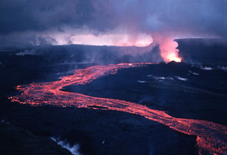 An incandescent lava flow travels downslope from the vent at the upper right during a September 1984 eruption from Krafla volcano. The eruption initially began on 4 September along an 8.5-km-long fissure; during later stages activity was localized along singular vents such as the one seen in this 15 September photo. A plume of gas is concentrated over the vent, but steam is also seen rising across much of this photograph, from recent lava flows.
Photo by Michael Ryan, 1984 (U.S. Geological Survey).
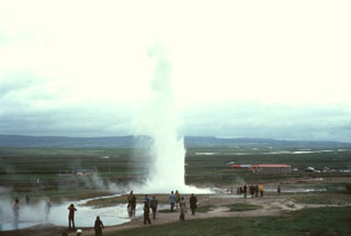 The Geysir thermal area, containing Iceland's largest geysers, lies in the Haukadalur basin, just east of the southern end of the extensive Oddnyjarhnjukur-Langjokull volcanic system. Here a geyser can be seen ejecting water and steam to about 20 m high.
Photo by Bill Rose, 1975 (Michigan Technological University).
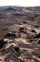 The Earth's largest known lava flow during historical time was erupted from the Lakagigar (Skaftár) fissure beginning June 8, 1783. Eruptive activity may have occurred at Grímsvötn caldera earlier in May. The 15 cu km Laki lavas were erupted over a 7-month period from a 27-km-long fissure system composed of 10 en-echelon fissures. Extensive crop damage and livestock losses caused a severe famine that resulted in the decimation of 22% of the population of Iceland.
 Copyrighted photo by Katia and Maurice Krafft, 1975.
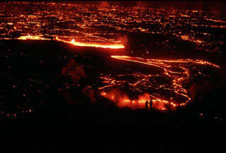 Scientists investigating a lava flow from Krafla volcano are silhouetted (lower right) against the glowing margin of the slowly advancing flow. This photo was taken on 5 September 1984, the day after the onset of an eruption from the Leihrnjúkur fissure. Cracks on the surface of the advancing flow reveal the still-molten interior.
Photo by Michael Ryan, 1984 (U.S. Geological Survey).
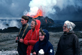 Three generations of an Icelandic family view the 1984 eruption of Krafla volcano as minor lava fountaining can be seen at the spatter cone in the background. The two-week eruption drew visitors from the nearby Myvatn area as well as other parts of Iceland to observe spectacular lava fountaining and slowly advancing lava flows.
Photo by Michael Ryan, 1984 (U.S. Geological Survey).
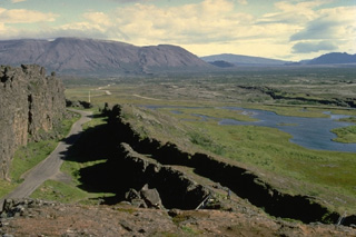 The Hengill volcanic system, mostly located SW of Thingvallavatn lake, consists of a series of NE-SW-trending fissure vents, crater rows, and small shield volcanoes occupying a strongly faulted graben. This view looks NE from the margin of a graben containing Hengill lava at Thingvellir, the site of Iceland's old parliament. The latest eruption of the Hengill volcanic system was radiocarbon dated at about 1900 years before present. Geothermally heated greenhouses, hot springs, and geysers are found at Hveragerdi.
 Copyrighted photo by Katia and Maurice Krafft.
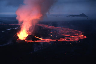 Lava fountains rising from a vent along an eruptive fissure at Krafla feed an incandescent lava flow that travels east and then turns toward the north. This 15 September 1984 photo was taken near the end of a two-week eruption. An 8.5-km-long fissure, initially active along its entire length, fed lava flows that covered 24 km2. The peak rising above the clouds on the right is Eilifur, which likely formed in the Pleistocene.
Photo by Michael Ryan, 1984 (U.S. Geological Survey).
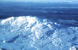 Snow-covered Hekla, one of Iceland's most prominent and active volcanoes, is seen here in an aerial view from the east. Toppgigur crater occupies the summit, in the middle of the ridge, and Axlargigur crater is seen here as a small peak along the summit ridge to the left (W). Repeated eruptions along an ENE-WSW-trending rift are responsible for Hekla's elongated profile. The 5.5-km-long Heklugja fissure cuts across the volcano. Lava flows from eruptions dating back to 1104 CE cover much of the volcano's flanks and are seen here fanning out from the ridge in all directions.
Photo by Oddur Sigurdsson, 1977 (Icelandic National Energy Authority).
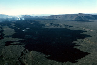 At their northern terminus the 1984 flows form a dark lava field north of Krafla caldera. The northernmost eruptive vents can be seen steaming at the upper left on 10 September 1984, about halfway through the two-week eruption. The flat-topped peak at the upper right is Gæsafjöll, one of Iceland's many table mountains, which formed as a result of repeated eruptions through a glacial icecap. The Hliðarfjall dome can be seen as a peak in the middle-background, and Bláfjall and Sellandafjall table mountains are on the horizon on the left, about 50 km away.
Photo by Michael Ryan, 1984 (U.S. Geological Survey).
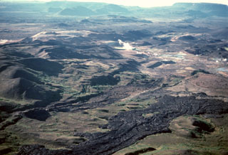 The dark lava flows in the foreground were emplaced during a series of eruptions known as the "Myvatn Fires" between 1724 and 1729. Lava flows covered much of the western floor of Krafla caldera and extended beyond the caldera to the north, and south into Myvatn lake. It is these southern flows seen here, with small lakes and a steam plume in the Namafjall and Myvatn geothermal areas at their distal end (center). The Hverfjall cone is just out of view to the top right.
Photo by Michael Ryan, 1984 (U.S. Geological Survey).
 The snow-covered Reykjanes volcanic system forms the SW tip of the Reykjanes Peninsula, where the Mid-Atlantic Ridge rises above sea level. It is the westernmost of a series of four closely spaced, NE-SW-trending, en-echelon fissure systems that extend diagonally across the Reykjanes Peninsula. Most of this system is covered by Holocene lavas, and eruptions occurred during the 13th century at several locations.
Photo by Oddur Sigurdsson, 1998 (Icelandic National Energy Authority).
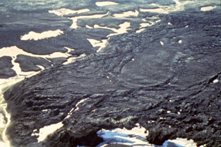 The silicic Hrafntinnuhraun eruption occurred in about 877 CE, producing about 0.18 km3 of lava and 0.4 km3 of tephra. An eruption column of up to 20 km high was associated with this Plinian eruption. The Hrafntinnuhraun lava flow stretches from the bottom left to top right in this image, with a stream running around its base on the left reflecting the sun.
Photo by Richie Williams, 1981 (U.S. Geological Survey).
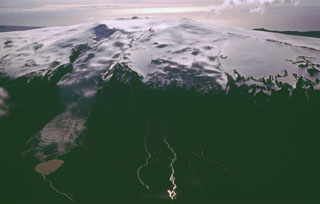 The summit ridge of Eyjafjallajökull is seen here in 1992 from the NW with a steep-sloped valley glacier descending at the left toward the Markafljot plain. The summit is truncated by a 2.5-km-wide, ice-filled caldera breached to the north (towards bottom left). Prior to 2010, the last eruption known from Eyjafjallajökull was during December 1821 to January 1823.
Photo by Oddur Sigurdsson, 1992 (Icelandic National Energy Authority).
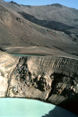 The 200-m-wide Viti maar crater, filled with a turquoise lake, was formed by phreatic explosions following a major Plinian eruption at Askja on 28-29 March 1875. Note the fault cutting the crater wall on the left. The dark lava flow in the background erupted from a vent on the NE caldera wall in 1921 and entered 4.5-km-wide Öskjuvatn lake, out of view to the right.
Photo by Michael Ryan, 1984 (U.S. Geological Survey).
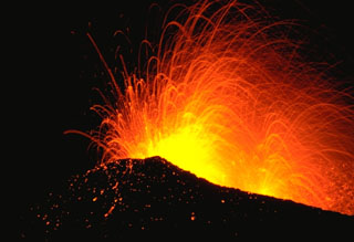 Incandescent bombs are ejected from the Oldugigar vent on the NNE flank of Hekla volcano during Strombolian activity in May 1970. This eruption began with vigorous explosive activity and was followed by effusion of lava flows that traveled to the SW, WNW, and N. The eruption lasted until July 1970.
Photo by Robert Citron, 1970 (Smithsonian Institution; courtesy of William Melson)
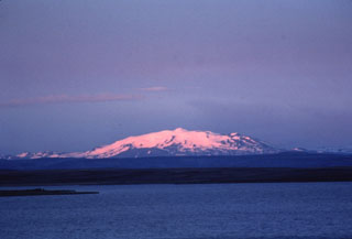 Twilight colors shade the snow-capped slopes of Hekla, one of Iceland's most active volcanoes. Hekla's elongated profile is apparent in this view from the north of the 5.5-km-long summit ridge. The Heklugjá fissure which runs along the length of the ridge has been the site of numerous historical eruptions and is often active along its full length.
Photo by Bill Rose, 1980 (Michigan Technological University).
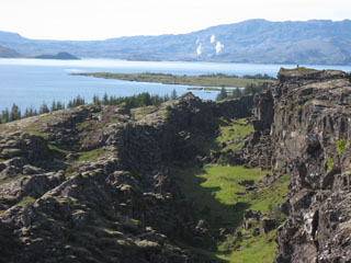 The Hengill central volcano in the right background rises above Thingvallavatn lake as seen from Thingvellir, the historical site of the Icelandic parliament. Steam clouds rise from the Nesjavellir geothermal area in this view from the northeast. Graben structures in the foreground cut the Thingvallahraun lava flow in the foreground, which was erupted about 10,000 years ago. The cone in the lake on the left is Sandey, a tuff ring formed in a phreatomagmatic eruption about 1,900 years ago.
Photo by Lee Siebert, 2008 (Smithsonian Institution).
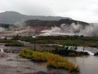 Steam rises from the Geysir geothermal area with the rhyolitic Laugarfjall lava dome in the middle ground behind the mounds of reddish hydrothermally altered clays. The basaltic Bjarnarfjell complex lies on the horizon. The Geysir volcanic system lends its name to geysers around the world and is one of the most frequently visited geological sites in Iceland. No eruptions are known from this volcanic system during the Holocene, although geothermal activity continues and the Strokkur geyser is in almost continuous activity.
Photo by Lee Siebert, 2008 (Smithsonian Institution).
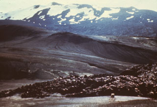 The elongated summit ridge of Hekla volcano is seen here from the west with a recent lava flow in the foreground. The 5.5-km-long Heklugja fissure cuts across the volcano and is often active along its full length during major eruptions. Repeated eruptions along this rift are responsible for Hekla's elongated ENE-WSW profile.
Photo courtesy of Jules Friedman (U.S. Geological Survey).
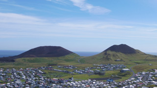 Vestmannaeyjar is a volcanic field about 20-25 km wide by 30-35 km long that forms an archipelago off the south coast of Iceland, about 60 km W of the town of Vik. The Eldfell (left) and Helgafell (right) scoria cones are seen here from the northern tip of Heimaey island in July 2019. Eldfell formed in 1973 and Helgafell around 5,900 BP.
Photo by Arianna Soldati, 2019.
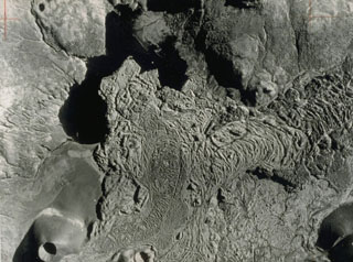 This vertical aerial photo (with south to the top) shows the Gráakúla scoria cone at the lower left, which erupted about 4,000 years ago and produced this lava flow that entered Selvallavatn lake. The flow is part of the Ljósufjöll volcanic system, which contains of a group of scoria cones and lava flows along a roughly 90-km-long WNW-ESE trend.
 Photo by Landmælingar Islands, courtesy of Jack Green (published in Green and Short, 1971).
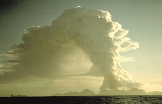 A column of steam and ash towers above the island of Heimaey on January 25, 1973, two days after the onset of its famous eruption. The mostly submarine Vestmannaeyjar is the southernmost volcanic system in the eastern volcanic zone of Iceland. It consists of a roughly 30 x 40 km group of volcanic islands and submarine cones occupying a shallow shelf off Iceland's southern coast. Vestmannaeyjar was the site of two of Iceland's most noted 20th-century eruptions, at Surtsey during 1963-67 and at Heimaey in 1973.
Copyrighted photo by Katia and Maurice Krafft, 1973.
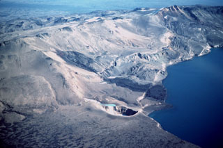 The dark 1921 Batshraun lava flow descends from a vent (left center) on the caldera rim into Öskjuvatn lake across several fault blocks related to caldera subsidence. This aerial view from the northwest shows the small 200-m-wide Viti maar (lower center), which formed during the 1875 eruption. Following slow subsidence of the caldera during and after the 1875 eruption, the depression was filled by the waters of Öskjuvatn lake. During the 1920's, several lava flows erupted from vents surrounding the caldera and flowed into the lake.
Photo by Michael Ryan, 1984 (U.S. Geological Survey).
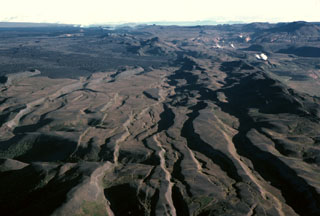 This north-looking view along fissures cutting Iceland's Krafla volcano illustrates crustal spreading processes where the Mid-Atlantic Ridge rises above sea level. The prominent horst-and-graben structures seen here are the result of repeated episodes of extensional rifting during which crustal blocks moved east and west, perpendicular to the line of faults. A period of pronounced crustal rifting occurred from 1975 to 1984, accompanied by nine small fissure eruptions. Steam can be seen in the upper left, rising above an active eruptive fissure in this September 1984 photo.
Photo by Michael Ryan, 1984 (U.S. Geological Survey).
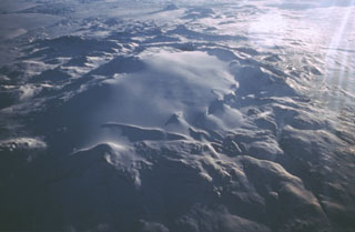 The Tungnafellsjökull central volcano lies immediately to the NW of the massive Vatnajökull icecap. The ~ 4 x 9 km summit caldera is largely filled by the Tungnafellsjökull glacier (center). An ice-free caldera to the SE, Vonarskarð, measures about 8 km in diameter; the caldera rim is visible in this image as a ridge at top left.
Photo by Oddur Sigurdsson, 1986 (Icelandic National Energy Authority).
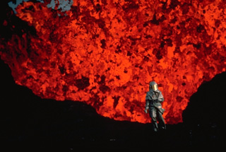 In 1984, Volcanologist Katia Krafft, wearing reflective heat-resistant gear, observes an incandescent lava fountain from Krafla volcano at close hand. The 1984 eruption marked the end of an intermittent decade-long eruptive episode from Krafla that began in 1975.
 Copyrighted photo by Katia and Maurice Krafft, 1984.
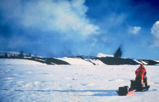 Two scientists of the Nordic Volcanological Institute doing monitoring fieldwork on 16 March 1980 were able to document the onset of activity when deflation started and an eruption began. Small dark lava fountains can be seen in a line on the left, indicating the location of a fissure, with a single larger fountain on the right which may represent a vent on the end of the fissure. Dark lava flows can be seen on the snow. A few minutes after this photo was taken a lava flow rapidly advanced in their direction, prompting them to retreat on their snowmobiles.
Photo courtesy of Gudmundar Sigvaldason, 1980 (Nordic Volcanological Institute, Reykjavík).
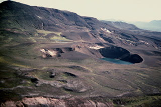 The 350-m-diameter Viti Crater (right center) and 14 other smaller craters were formed during 1724 at the start of a five-year period of rifting and eruptions known as the "Myvatn Fires." Krafla mountain, located east of Viti (upper left), is composed of hyaloclastic rocks formed during subglacial eruptions. It is one of the most prominent features in the Krafla caldera. The 1724 eruption forming Viti maar produced tephra fall over 12 km.
Photo by Michael Ryan, 1984 (U.S. Geological Survey).
 The Strockur geyser is a prominent feature of the Geysir geothermal field, located south of Hveravellir central volcano. The volcano lies beneath the Langjökull icecap at the northern end of an active volcanic zone that extends to the NE from the Reykjanes Peninsula. Several shield volcanoes have been constructed along flank fissure zones, and postglacial lava flows flank Langjökull on the northern, western, and eastern sides. The massive Hallmundahraun lava flow, which covers 200 km2, was erupted shortly after 900 CE.
 From the collection of Maurice and Katia Krafft.
 The flanks of the largely Pleistocene rhyolitic central volcano Kerlingarfjöll have been deeply dissected by glaciers, giving it a rugged appearance. This approximately 10-km-wide volcanic edifice is seen here from the NNE, separated by a topographic low (foreground) from Hofsjökull. A Holocene eruption between the two edifices produced the Illahraun lava flow. This lava flow travelled more than 20 km S and is petrologically linked to Hofsjökull. Kerlingarfjöll has a large geothermal area with vigorous fumaroles.
Photo by Oddur Sigurdsson, 1998 (Icelandic National Energy Authority).
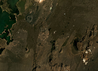 Heiðarsporðar (Heidarspordar) is about 22 km in length, with a smaller area shown in this June 2019 Planet Labs satellite image monthly mosaic (N is at the top; this image is approximately 20 km across). Around 2,200 years ago it produced a lava field around 220 km2 in size, reaching 60 km away from the source. The darker area in the upper left corner is Mývatn lake.
Satellite image courtesy of Planet Labs Inc., 2019 (https://www.planet.com/).
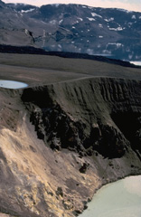 The steep-walled Viti crater in the foreground was formed during an eruption of Askja that began on January 1, 1875. A powerful plinian phase beginning on March 28 was preceded by caldera collapse that continued slowly for several years. Viti ("Hell") crater, now filled by a small lake, was created by phreatic eruptions that followed the plinian explosions.
Copyrighted photo by Katia and Maurice Krafft, 1974.
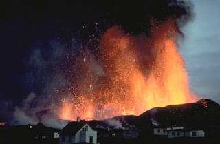 Lava fountains tower above the town of Vestmannaeyjar in March 1973. The eruption began on January 23, 1973, with explosive ejections from a NNE-SSW-trending, partly submarine fissure cutting Helgafell cone. Lava fountains built the Eldfell cinder cone and fed lava flows that reached the sea. Tephra buried more than 100 houses, and lava flows inundated parts of the town and threatened its harbor. The effects of vigorous efforts to slow the progress of the lava by spraying it with cold seawater are debated, but the flow stabilized at a point that improved the natural harbor.
 Copyrighted photo by Katia and Maurice Krafft, 1973.
This is a compilation of Iceland volcano information sources, such as official monitoring or other government agencies.
| Volcano Observatories | |
|---|---|
| Veðurstofa Íslands | |
| - Icelandic Meteorological Office (IMO) English | |
| Additional Information Sources | |
|---|---|
| Catalogue of Icelandic Volcanoes | |
| FUTUREVOLC | |
| Nordic Volcanological Center (NordVulk) | |
| Volcanic Ash Advisory Center | |
|---|---|
| London Volcanic Ash Advisory Centre (VAAC) | |
| - London VAAC Archive | |
| - London VAAC Notices | |